
Topografische kaart Kewstoke
Interactieve kaart
Klik op de kaart om de hoogte weer te geven.
Over deze kaart
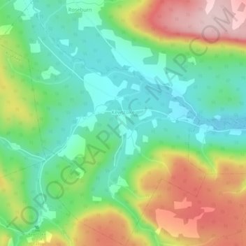
Naam: Topografische kaart Kewstoke, hoogte, reliëf.
Gemiddelde hoogte: 161 m
Minimale hoogte: 57 m
Maximale hoogte: 333 m
Andere topografische kaarten
Klik op een kaart om zijn topografie, zijn hoogte en zijn reliëf te bekijken.
West Bay
Canada > Nova Scotia > Municipality of the County of Inverness
West Bay, Municipality of the County of Inverness, Inverness County, Nova Scotia, Canada
Gemiddelde hoogte: 109 m
Big Brook
Canada > Nova Scotia > Municipality of the County of Inverness
Big Brook, Municipality of the County of Inverness, Inverness County, Nova Scotia, Canada
Gemiddelde hoogte: 127 m
Mull River
Canada > Nova Scotia > Municipality of the County of Inverness > Mabou
Mull River, Mabou, Municipality of the County of Inverness, Inverness County, Nova Scotia, Canada
Gemiddelde hoogte: 83 m
Dunmore
Canada > Nova Scotia > Municipality of the County of Inverness
Dunmore, Municipality of the County of Inverness, Inverness County, Nova Scotia, Canada
Gemiddelde hoogte: 28 m
Point Cross
Canada > Nova Scotia > Municipality of the County of Inverness > Point Cross
Point Cross, Municipality of the County of Inverness, Inverness County, Nova Scotia, Canada
Gemiddelde hoogte: 97 m
Mabou
Canada > Nova Scotia > Municipality of the County of Inverness > Mabou
Mabou, Municipality of the County of Inverness, Inverness County, Nova Scotia, Canada
Gemiddelde hoogte: 81 m
Gillis Cove
Canada > Nova Scotia > Municipality of the County of Inverness
Gillis Cove, Municipality of the County of Inverness, Inverness County, Nova Scotia, Canada
Gemiddelde hoogte: 13 m
Whycocomagh
Canada > Nova Scotia > Municipality of the County of Inverness
Whycocomagh, Municipality of the County of Inverness, Inverness County, Nova Scotia, B0E 3M0, Canada
Gemiddelde hoogte: 135 m
Pleasant Bay
Canada > Nova Scotia > Municipality of the County of Inverness
Pleasant Bay, Municipality of the County of Inverness, Inverness County, Nova Scotia, B0E 2P0, Canada
Gemiddelde hoogte: 80 m