Geolokaliseren

Topografische kaart Pitigliano

Interactieve kaart

Klik op de kaart om de hoogte weer te geven.

Pitigliano

The municipality area of Pitigliano, while presenting different local situations on the basis of 'topography is characterized by rather low winter temperatures, which can occur during prolonged periods, despite the daily maximum values are often pleasing. On the contrary, in summer the heat can be very intense, though usually accompanied by low relative humidity.

Wikipedia (CC-BY-SA 3.0)

Over deze kaart

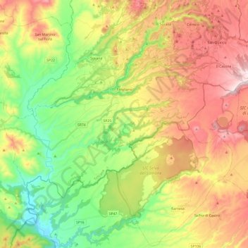
Naam: Topografische kaart Pitigliano, hoogte, reliëf.

Locatie: Pitigliano, Unione di Comuni Montani Colline del Fiora, Grosseto, Tuscany, 58017, Italy (42.55700 11.55620 42.66287 11.79721)

Gemiddelde hoogte: 331 m

Minimale hoogte: 98 m

Maximale hoogte: 620 m

Andere topografische kaarten

Klik op een kaart om zijn topografie, zijn hoogte en zijn reliëf te bekijken.

Stazione di Giuncarico

Italy > Tuscany > Grosseto > Castellaccia

Gemiddelde hoogte: 39 m

Giuncarico

Italy > Tuscany > Grosseto

Gemiddelde hoogte: 51 m

Marina di Grosseto

Italy > Tuscany > Grosseto > Grosseto

Gemiddelde hoogte: 2 m

Albinia

Italy > Tuscany > Grosseto > Orbetello

Gemiddelde hoogte: 1 m

San Valentino

Italy > Tuscany > Grosseto

Gemiddelde hoogte: 457 m

Ribolla

Italy > Tuscany > Grosseto

Gemiddelde hoogte: 74 m

Isola Rossa

Italy > Tuscany > Grosseto

Gemiddelde hoogte: 35 m

Marsiliana

Italy > Tuscany > Grosseto

Gemiddelde hoogte: 51 m