
Doe een donatie
Rust jezelf uit voor je volgende avontuur:
Als Amazon-partner verdient deze site een commissie op in aanmerking komende aankopen, zonder extra kosten voor jou.
Topografische kaart Winnemucca
Klik op de kaart om de hoogte weer te geven.
Doe een donatie
Rust jezelf uit voor je volgende avontuur:
Als Amazon-partner verdient deze site een commissie op in aanmerking komende aankopen, zonder extra kosten voor jou.
Over deze kaart
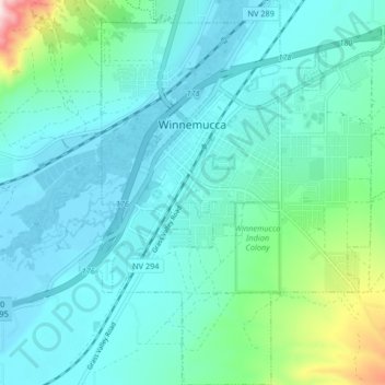
Naam: Topografische kaart Winnemucca, hoogte, reliëf.
Locatie: Winnemucca, Humboldt County, Nevada, 89445, United States (40.93026 -117.75904 40.99255 -117.68692)
Gemiddelde hoogte: 1.365 m
Minimale hoogte: 1.299 m
Maximale hoogte: 1.701 m
Doe een donatie
Rust jezelf uit voor je volgende avontuur:
Als Amazon-partner verdient deze site een commissie op in aanmerking komende aankopen, zonder extra kosten voor jou.
Andere topografische kaarten
Klik op een kaart om zijn topografie, zijn hoogte en zijn reliëf te bekijken.
Doe een donatie
Rust jezelf uit voor je volgende avontuur:
Als Amazon-partner verdient deze site een commissie op in aanmerking komende aankopen, zonder extra kosten voor jou.
McDermitt
United States > Nevada > Humboldt County
The community is on U.S. Highway 95, 73 miles (117 km) north of Winnemucca. The elevation of McDermitt is 4,432 feet (1,351 m) above sea level.
Gemiddelde hoogte: 1.359 m
Doe een donatie
Rust jezelf uit voor je volgende avontuur:
Als Amazon-partner verdient deze site een commissie op in aanmerking komende aankopen, zonder extra kosten voor jou.
Winnemucca
United States > Nevada > Humboldt County > Winnemucca > Winnemucca
Gemiddelde hoogte: 1.403 m