
Doe een donatie
Rust jezelf uit voor je volgende avontuur:
Als Amazon-partner verdient deze site een commissie op in aanmerking komende aankopen, zonder extra kosten voor jou.
Topografische kaart Kazbegi
Klik op de kaart om de hoogte weer te geven.
Doe een donatie
Rust jezelf uit voor je volgende avontuur:
Als Amazon-partner verdient deze site een commissie op in aanmerking komende aankopen, zonder extra kosten voor jou.
Kazbegi
Kazbek is located on the Khokh Range, a mountain range which runs north of the Greater Caucasus Range, and which is pierced by the gorges of the Ardon and the Terek. At its eastern foot runs the Georgian Military Road through the pass of Darial 2,378 meters (7,805 feet). The mountain itself lies along the edge of the Borjomi–Kazbegi Fault (which is a northern sub-ending of the North Anatolian Fault). The region is highly active tectonically, with numerous small earthquakes occurring at regular intervals. An active geothermal/hot spring system also surrounds the mountain. Kazbek is a potentially active volcano, built up of trachyte and sheathed with lava, and has the shape of a double cone, whose base lies at an altitude of 1,770 meters (5,800 feet). Kazbek is the highest of the volcanic cones of the Kazbegi volcanic group which also includes Mount Khabarjina (3,142 metres).
Doe een donatie
Rust jezelf uit voor je volgende avontuur:
Als Amazon-partner verdient deze site een commissie op in aanmerking komende aankopen, zonder extra kosten voor jou.
Over deze kaart
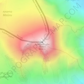
Naam: Topografische kaart Kazbegi, hoogte, reliëf.
Gemiddelde hoogte: 4.324 m
Minimale hoogte: 3.634 m
Maximale hoogte: 5.032 m
Doe een donatie
Rust jezelf uit voor je volgende avontuur:
Als Amazon-partner verdient deze site een commissie op in aanmerking komende aankopen, zonder extra kosten voor jou.
Andere topografische kaarten
Klik op een kaart om zijn topografie, zijn hoogte en zijn reliëf te bekijken.