
Topografische kaart De Smet
Interactieve kaart
Klik op de kaart om de hoogte weer te geven.
De Smet
U.S. Route 95 passes nearby and the community is located about a mile (1.6 km) south of Tensed, which was originally also to be titled Desmet before the name was ordered to be reversed and was subsequently misspelled by the post office. Latah Creek flows between the two communities. De Smet has a post office with a ZIP code of 83824. As of the 2010 census, its population was 145, and its elevation is approximately 2,600 feet (790 m) above sea level.
Over deze kaart
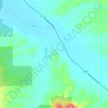
Naam: Topografische kaart De Smet, hoogte, reliëf.
Locatie: De Smet, Benewah County, Idaho, 83824, United States (47.12601 -116.93572 47.16601 -116.89572)
Gemiddelde hoogte: 794 m
Minimale hoogte: 771 m
Maximale hoogte: 894 m
Andere topografische kaarten
Klik op een kaart om zijn topografie, zijn hoogte en zijn reliëf te bekijken.
Tensed
United States > Idaho > Benewah County
Tensed is located at 47°9′37″N 116°55′27″W / 47.16028°N 116.92417°W / 47.16028; -116.92417 (47.160284, -116.924304), at an elevation of 2,562 feet (781 m) above sea level.
Gemiddelde hoogte: 785 m