
Topografische kaart Owls Head
Interactieve kaart
Klik op de kaart om de hoogte weer te geven.
Over deze kaart
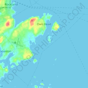
Naam: Topografische kaart Owls Head, hoogte, reliëf.
Locatie: Owls Head, Knox County, Maine, 04854, United States (44.01220 -69.13335 44.10654 -68.99374)
Gemiddelde hoogte: 4 m
Minimale hoogte: -2 m
Maximale hoogte: 57 m
Andere topografische kaarten
Klik op een kaart om zijn topografie, zijn hoogte en zijn reliëf te bekijken.
North Haven Island
United States > Maine > Knox County > North Haven
North Haven Island, North Haven, Knox County, Maine, 04853, United States
Gemiddelde hoogte: 6 m
Penobscot Bay
United States > Maine > Knox County > North Haven
Penobscot Bay, North Haven, Knox County, Maine, United States
Gemiddelde hoogte: 0 m
Glen Cove
United States > Maine > Knox County > Rockport
Glen Cove, Rockport, Knox County, Maine, 04841, United States
Gemiddelde hoogte: 30 m
Rockland
United States > Maine > Knox County
Rockland, Knox County, Maine, 04841, United States
Gemiddelde hoogte: 37 m
Vinalhaven
United States > Maine > Knox County
Vinalhaven, Knox County, Maine, 04863, United States
Gemiddelde hoogte: 2 m