
Topografische kaart Bhubaneshwar
Interactieve kaart
Klik op de kaart om de hoogte weer te geven.
Over deze kaart
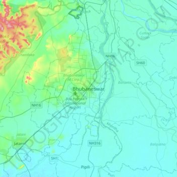
Naam: Topografische kaart Bhubaneshwar, hoogte, reliëf.
Gemiddelde hoogte: 30 m
Minimale hoogte: 6 m
Maximale hoogte: 199 m
Bhubaneswar is in Khordha district of Odisha. It is in the eastern coastal plains, along the axis of the Eastern Ghats mountains. The city has an average altitude of 45 m (148 ft) above sea level. It lies southwest of the Mahanadi River that forms the northern boundary of Bhubaneswar metropolitan area, within its delta.
Andere topografische kaarten
Klik op een kaart om zijn topografie, zijn hoogte en zijn reliëf te bekijken.
Bhubaneswar Municipal Corporation
India > Odisha > Bhubaneswar (M.Corp.) > Bhubaneswar Municipal Corporation
Bhubaneswar Municipal Corporation, Bhubaneswar (M.Corp.), Khordha, Odisha, India
Gemiddelde hoogte: 37 m