
Topografische kaart Purdy
Interactieve kaart
Klik op de kaart om de hoogte weer te geven.
Over deze kaart
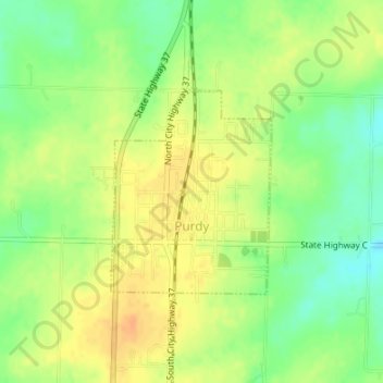
Naam: Topografische kaart Purdy, hoogte, reliëf.
Locatie: Purdy, Barry County, Missouri, 65734, United States (36.81245 -93.92789 36.82683 -93.91373)
Gemiddelde hoogte: 445 m
Minimale hoogte: 425 m
Maximale hoogte: 461 m
US Department of the Interior Original Surveys and USGS Topographical map showing the Butterfield Overland Mail Route
Andere topografische kaarten
Klik op een kaart om zijn topografie, zijn hoogte en zijn reliëf te bekijken.
Jenkins
United States > Missouri > Barry County
Jenkins, Barry County, Missouri, United States
Gemiddelde hoogte: 359 m
Ridgley
United States > Missouri > Barry County
Ridgley, Barry County, Missouri, United States
Gemiddelde hoogte: 432 m
Madry
United States > Missouri > Barry County
Madry, Barry County, Missouri, United States
Gemiddelde hoogte: 460 m
Pioneer
United States > Missouri > Barry County
Pioneer, Barry County, Missouri, 64842, United States
Gemiddelde hoogte: 385 m
McDowell
United States > Missouri > Barry County
McDowell, Barry County, Missouri, United States
Gemiddelde hoogte: 385 m
Eagle Rock
United States > Missouri > Barry County
Eagle Rock, Barry County, Missouri, 65641, United States
Gemiddelde hoogte: 322 m
Butterfield
United States > Missouri > Barry County
Butterfield, Barry County, Missouri, 65623, United States
Gemiddelde hoogte: 463 m
Seligman
United States > Missouri > Barry County
Seligman, Barry County, Missouri, United States
Gemiddelde hoogte: 467 m
Wheaton
United States > Missouri > Barry County
Wheaton, Barry County, Missouri, United States
Gemiddelde hoogte: 420 m
Golden
United States > Missouri > Barry County
Golden, Barry County, Missouri, 65658, United States
Gemiddelde hoogte: 326 m
Exeter
United States > Missouri > Barry County
Exeter, Barry County, Missouri, 65647, United States
Gemiddelde hoogte: 466 m
Monett
United States > Missouri > Barry County
Monett, Barry County, Missouri, 65708, United States
Gemiddelde hoogte: 416 m
Roaring River State Park
United States > Missouri > Barry County
Roaring River State Park, Barry County, Missouri, United States
Gemiddelde hoogte: 372 m
Shell Knob
United States > Missouri > Barry County
Shell Knob, Barry County, Missouri, United States
Gemiddelde hoogte: 306 m
Reed Mountain
United States > Missouri > Barry County
Reed Mountain, Barry County, Missouri, 65745, United States
Gemiddelde hoogte: 441 m
Washburn
United States > Missouri > Barry County
Washburn, Barry County, Missouri, United States
Gemiddelde hoogte: 456 m
Cassville
United States > Missouri > Barry County
Cassville, Barry County, Missouri, United States
Gemiddelde hoogte: 427 m