
Topografische kaart Tân Phú District
Interactieve kaart
Klik op de kaart om de hoogte weer te geven.
Over deze kaart
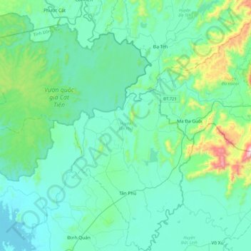
Naam: Topografische kaart Tân Phú District, hoogte, reliëf.
Locatie: Tân Phú District, Đồng Nai Province, Vietnam (11.17674 107.17709 11.58198 107.54190)
Gemiddelde hoogte: 186 m
Minimale hoogte: 51 m
Maximale hoogte: 973 m
Andere topografische kaarten
Klik op een kaart om zijn topografie, zijn hoogte en zijn reliëf te bekijken.
Định Quán
Vietnam > Dong Nai province > Định Quán District
Định Quán, Định Quán District, Đồng Nai Province, Vietnam
Gemiddelde hoogte: 141 m
Xã Thanh Sơn
Vietnam > Dong Nai province > Định Quán District
Xã Thanh Sơn, Định Quán District, Đồng Nai Province, Vietnam
Gemiddelde hoogte: 125 m
Long Thành District
Long Thành District, Đồng Nai Province, Vietnam
Gemiddelde hoogte: 42 m
Trảng Dài Ward
Vietnam > Dong Nai province > Bien Hoa City
Trảng Dài Ward, Biên Hòa City, Đồng Nai Province, Vietnam
Gemiddelde hoogte: 32 m
Xuân Lộc District
Xuân Lộc District, Đồng Nai Province, 76615, Vietnam
Gemiddelde hoogte: 123 m
Long Khánh City
Vietnam > Dong Nai province > Long Khánh City
Long Khánh City, Dong Nai Province, Vietnam
Gemiddelde hoogte: 161 m
Phường Xuân Trung
Vietnam > Dong Nai province > Long Khánh City
Phường Xuân Trung, Long Khánh City, Dong Nai Province, Vietnam
Gemiddelde hoogte: 167 m
Cát Tiên National Park
Cát Tiên National Park, Tân Phú District, Dong Nai province, Vietnam
Gemiddelde hoogte: 243 m
Bien Hoa
Vietnam > Dong Nai province > Bien Hoa City > Bien Hoa
Bien Hoa, Bien Hoa City, Dong Nai province, 060, Vietnam
Gemiddelde hoogte: 24 m
Thanh Hóa
Vietnam > Dong Nai province > Thanh Hóa
Thanh Hóa, Trảng Bom District, Dong Nai province, 810000, Vietnam
Gemiddelde hoogte: 52 m