Geolokaliseren
👉 Easily get elevation data in JSON, GeoTIFF and KML formats using Elevation API
Bedankt voor het steunen van deze site ❤️
Doe een donatie

Rust jezelf uit voor je volgende avontuur:

Als Amazon-partner verdient deze site een commissie op in aanmerking komende aankopen, zonder extra kosten voor jou.

Topografische kaart Loveland

Klik op de kaart om de hoogte weer te geven.

👉 Easily get elevation data in JSON, GeoTIFF and KML formats using Elevation API
Bedankt voor het steunen van deze site ❤️
Doe een donatie

Rust jezelf uit voor je volgende avontuur:

Als Amazon-partner verdient deze site een commissie op in aanmerking komende aankopen, zonder extra kosten voor jou.

Over deze kaart

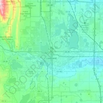
Naam: Topografische kaart Loveland, hoogte, reliëf.

Locatie: Loveland, Larimer County, Colorado, United States (40.34907 -105.15979 40.46587 -104.96208)

Gemiddelde hoogte: 1.547 m

Minimale hoogte: 1.472 m

Maximale hoogte: 1.926 m

👉 Easily get elevation data in JSON, GeoTIFF and KML formats using Elevation API
Bedankt voor het steunen van deze site ❤️
Doe een donatie

Rust jezelf uit voor je volgende avontuur:

Als Amazon-partner verdient deze site een commissie op in aanmerking komende aankopen, zonder extra kosten voor jou.

Andere topografische kaarten

Klik op een kaart om zijn topografie, zijn hoogte en zijn reliëf te bekijken.

Estes Park

United States > Colorado > Larimer County

Estes Park sits at an elevation of 7,522 feet (2,293 m) on the front range of the Rocky Mountains at the eastern entrance of the Rocky Mountain National Park. Its location is 40°22′22″N 105°31′09″W / 40.372856°N 105.519136°W / 40.372856; -105.519136. Its north, south and east extremities…

Gemiddelde hoogte: 2.543 m

Estes Park

United States > Colorado > Larimer County

Estes Park sits at an elevation of 7,522 feet (2,293 m) on the front range of the Rocky Mountains at the eastern entrance of the Rocky Mountain National Park. Its north, south and east extremities border the Roosevelt National Forest. Lumpy Ridge lies immediately north of Estes Park.

Gemiddelde hoogte: 2.420 m

Livermore

United States > Colorado > Larimer County

Gemiddelde hoogte: 1.814 m

Glen Echo

United States > Colorado > Larimer County > Rustic

Gemiddelde hoogte: 2.418 m

Wellington

United States > Colorado > Larimer County

Gemiddelde hoogte: 1.586 m

Boyd Lake

United States > Colorado > Larimer County > Loveland

Gemiddelde hoogte: 1.517 m

Drake

United States > Colorado > Larimer County

Gemiddelde hoogte: 2.140 m

Berthoud

United States > Colorado > Larimer County

Gemiddelde hoogte: 1.545 m

Masonville

United States > Colorado > Larimer County

Gemiddelde hoogte: 1.694 m

Bellvue

United States > Colorado > Larimer County

Gemiddelde hoogte: 1.597 m

Berthoud

United States > Colorado > Larimer County

Gemiddelde hoogte: 1.566 m

Estes Park

United States > Colorado > Larimer County

Estes Park sits at an elevation of 7,522 feet (2,293 m) on the front range of the Rocky Mountains at the eastern entrance of the Rocky Mountain National Park. Its location is 40°22′22″N 105°31′09″W / 40.372856°N 105.519136°W / 40.372856; -105.519136. Its north, south and east extremities…

Gemiddelde hoogte: 2.409 m

La Poudre Pass

United States > Colorado > Larimer County

La Poudre Pass (elevation 10,184 ft (3,104 m)), a high mountain pass, is located in the Rocky Mountains of northern Colorado in the United States.

Gemiddelde hoogte: 3.218 m

Bellvue

United States > Colorado > Larimer County

Gemiddelde hoogte: 1.597 m

Berthoud

United States > Colorado > Larimer County

Gemiddelde hoogte: 1.560 m

Glen Haven

United States > Colorado > Larimer County

Gemiddelde hoogte: 2.349 m

Bedankt voor het steunen van deze site ❤️
Doe een donatie

Rust jezelf uit voor je volgende avontuur:

Als Amazon-partner verdient deze site een commissie op in aanmerking komende aankopen, zonder extra kosten voor jou.

La Poudre Pass

United States > Colorado > Larimer County

La Poudre Pass (elevation 10,184 ft (3,104 m)), a high mountain pass, is located in the Rocky Mountains of northern Colorado in the United States.

Gemiddelde hoogte: 3.218 m

Chimney Rock

United States > Colorado > Larimer County

Gemiddelde hoogte: 2.374 m

Sprague Lake

United States > Colorado > Larimer County

Gemiddelde hoogte: 2.728 m

Sprague Lake

United States > Colorado > Larimer County

Gemiddelde hoogte: 2.728 m

Bedankt voor het steunen van deze site ❤️
Doe een donatie

Rust jezelf uit voor je volgende avontuur:

Als Amazon-partner verdient deze site een commissie op in aanmerking komende aankopen, zonder extra kosten voor jou.

Pingree Hill

United States > Colorado > Larimer County

Gemiddelde hoogte: 2.532 m

Cameron Peak

United States > Colorado > Larimer County

Gemiddelde hoogte: 3.381 m

Bedankt voor het steunen van deze site ❤️
Doe een donatie

Rust jezelf uit voor je volgende avontuur:

Als Amazon-partner verdient deze site een commissie op in aanmerking komende aankopen, zonder extra kosten voor jou.

Warren Lake

United States > Colorado > Larimer County > Fort Collins

Gemiddelde hoogte: 1.524 m

Bedankt voor het steunen van deze site ❤️
Doe een donatie

Rust jezelf uit voor je volgende avontuur:

Als Amazon-partner verdient deze site een commissie op in aanmerking komende aankopen, zonder extra kosten voor jou.

Loveland

United States > Colorado > Larimer County

Gemiddelde hoogte: 1.502 m

Campion

United States > Colorado > Larimer County

Gemiddelde hoogte: 1.558 m

Estes Park

United States > Colorado > Larimer County

Estes Park sits at an elevation of 7,658 feet (2,334 m) on the Front Range of the Rocky Mountains at the eastern entrance of the Rocky Mountain National Park. Its north, south and east extremities border the Roosevelt National Forest. Lumpy Ridge lies immediately north of Estes Park.

Gemiddelde hoogte: 2.543 m

Sundance Mountain

United States > Colorado > Larimer County

Gemiddelde hoogte: 3.522 m

Bedankt voor het steunen van deze site ❤️
Doe een donatie

Rust jezelf uit voor je volgende avontuur:

Als Amazon-partner verdient deze site een commissie op in aanmerking komende aankopen, zonder extra kosten voor jou.

Estes Park

United States > Colorado > Larimer County

Estes Park sits at an elevation of 7,522 feet (2,293 m) on the front range of the Rocky Mountains at the eastern entrance of the Rocky Mountain National Park. Its north, south and east extremities border the Roosevelt National Forest. Lumpy Ridge lies immediately north of Estes Park.

Gemiddelde hoogte: 2.429 m

Mount Evelyn

United States > Colorado > Larimer County

Gemiddelde hoogte: 2.206 m

Arthur's Rock

United States > Colorado > Larimer County

Gemiddelde hoogte: 1.890 m

Bellvue

United States > Colorado > Larimer County

Gemiddelde hoogte: 1.597 m

Rust jezelf uit voor je volgende avontuur:

📱Telefoonhouders Fiets - Bekijk topografische kaarten veilig op je stuur
📘Trekking Gidsen - Praktische gidsen voor meerdaagse tochten
🔋Outdoor Powerbanks - Laad je smartphone of GPS op in de natuur
👣Stappentellers - Meet je dagelijkse activiteit eenvoudig
🧣Nekwarmers & Buffs - Multifunctionele bescherming tegen wind en kou

Als Amazon-partner verdient deze site een commissie op in aanmerking komende aankopen, zonder extra kosten voor jou.