
Topografische kaart Haverhill
Interactieve kaart
Klik op de kaart om de hoogte weer te geven.
Over deze kaart
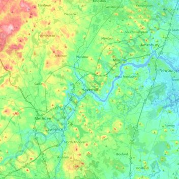
Naam: Topografische kaart Haverhill, hoogte, reliëf.
Locatie: Haverhill, Essex County, Massachusetts, 01830, United States (42.61778 -71.23677 42.93778 -70.91677)
Gemiddelde hoogte: 45 m
Minimale hoogte: -5 m
Maximale hoogte: 178 m
According to the United States Census Bureau, the city has a total area of 35.6 square miles (92.3 km2), of which 33.0 square miles (85.4 km2) is land and 2.7 square miles (6.9 km2), or 7.47%, is water. The city ranks 60th in the Commonwealth in terms of land area, and is the largest city or town in Essex County. Haverhill is drained by the Little and Merrimack rivers, the latter separating the Bradford section of town from the rest of Haverhill. The highest point in the city is found on Ayers Hill, a drumlin with two knobs of almost equal elevation of at least 335 feet (102 m), according to the most recent (2011-2012) USGS 7.5-minute topographical map. The city also has several ponds and lakes, as well as three golf courses.
Andere topografische kaarten
Klik op een kaart om zijn topografie, zijn hoogte en zijn reliëf te bekijken.
Rocks Village
United States > Massachusetts > Essex County > Haverhill
Rocks Village, Haverhill, Essex County, Massachusetts, 01860, United States
Gemiddelde hoogte: 28 m
Chadwick Pond
United States > Massachusetts > Essex County > Haverhill
Chadwick Pond, Haverhill, Essex County, Massachusetts, United States
Gemiddelde hoogte: 43 m