
Topografische kaart Seguin Township
Interactieve kaart
Klik op de kaart om de hoogte weer te geven.
Over deze kaart
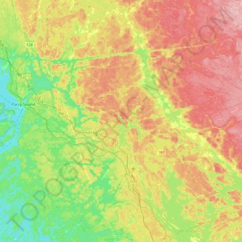
Naam: Topografische kaart Seguin Township, hoogte, reliëf.
Gemiddelde hoogte: 247 m
Minimale hoogte: 172 m
Maximale hoogte: 336 m
Andere topografische kaarten
Klik op een kaart om zijn topografie, zijn hoogte en zijn reliëf te bekijken.
Ellsmere Island
Canada > Ontario > Parry Sound District > The Archipelago Township
Ellsmere Island, The Archipelago Township, Parry Sound District, Central Ontario, Ontario, Canada
Gemiddelde hoogte: 197 m
Novar
Canada > Ontario > Parry Sound District > Perry Township
Novar, Perry Township, Parry Sound District, Central Ontario, Ontario, P0A 1R0, Canada
Gemiddelde hoogte: 348 m
Doe Lake
Canada > Ontario > Parry Sound District > Ryerson Township
Doe Lake, Ryerson Township, Parry Sound District, Central Ontario, Ontario, Canada
Gemiddelde hoogte: 311 m
McKellar
Canada > Ontario > Parry Sound District > McKellar Township
McKellar, McKellar Township, Parry Sound District, Central Ontario, Ontario, P0G 1C0, Canada
Gemiddelde hoogte: 250 m
Carson Bay
Canada > Ontario > Parry Sound District > The Archipelago Township
Carson Bay, The Archipelago Township, Parry Sound District, Central Ontario, Ontario, Canada
Gemiddelde hoogte: 187 m
Parry Sound
Canada > Ontario > Parry Sound District > Parry Sound
Parry Sound, Parry Sound District, Central Ontario, Ontario, P2A 1B2, Canada
Gemiddelde hoogte: 202 m
Island Lake
Canada > Ontario > Parry Sound District
Island Lake, Parry Sound District, Central Ontario, Ontario, Canada
Gemiddelde hoogte: 223 m
Emsdale
Canada > Ontario > Parry Sound District > Perry Township > Emsdale
Emsdale, Perry Township, Parry Sound District, Central Ontario, Ontario, P0A 1J0, Canada
Gemiddelde hoogte: 349 m
Whitestone
Canada > Ontario > Parry Sound District
Whitestone, Parry Sound District, Central Ontario, Ontario, P0A 1G0, Canada
Gemiddelde hoogte: 249 m