
Topografische kaart Upper Saucon
Interactieve kaart
Klik op de kaart om de hoogte weer te geven.
Upper Saucon
According to the United States Census Bureau, the township has a total area of 24.6 square miles (63.7 km2), of which 24.5 square miles (63.4 km2) are land and 0.2 square miles (0.4 km2), or 0.59%, are water. Its boundary with Salisbury Township is located on South Mountain. Elevations range from 340 feet (100 m) in Spring Valley to 1,042 feet (318 m) at Bauer Rock atop South Mountain in Big Rock County Park. Upper Saucon is in the Delaware River watershed and is drained by Saucon Creek into the Lehigh River, except for a very small area in the extreme south just southwest of Locust Valley, which is drained by Unami Creek into Perkiomen Creek and the Schuylkill River.
Over deze kaart
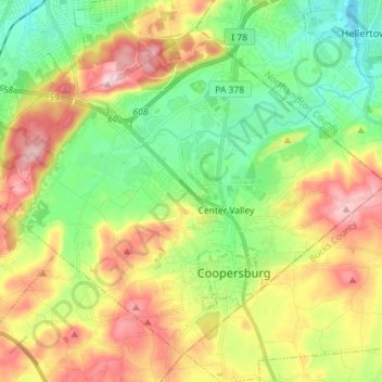
Naam: Topografische kaart Upper Saucon, hoogte, reliëf.
Locatie: Upper Saucon, Lehigh County, Pennsylvania, United States (40.48798 -75.47584 40.58115 -75.33305)
Gemiddelde hoogte: 175 m
Minimale hoogte: 77 m
Maximale hoogte: 316 m
Andere topografische kaarten
Klik op een kaart om zijn topografie, zijn hoogte en zijn reliëf te bekijken.