
Doe een donatie
Rust jezelf uit voor je volgende avontuur:
Als Amazon-partner verdient deze site een commissie op in aanmerking komende aankopen, zonder extra kosten voor jou.
Topografische kaart Baglung
Klik op de kaart om de hoogte weer te geven.
Doe een donatie
Rust jezelf uit voor je volgende avontuur:
Als Amazon-partner verdient deze site een commissie op in aanmerking komende aankopen, zonder extra kosten voor jou.
Baglung
Baglung enjoys warm summers and mild winters. Annual average temperatures range from a maximum of 26.6 °C (79.9 °F) and a minimum of 19.1 °C (66.4 °F). Highs above 35 °C (95 °F) and lows below 0 °C (32 °F) are rare. The average annual rainfall recorded is 1,060.9 mm (41.77 in) in 1982. Rainfall is heavily affected by the monsoon and most of it occurs during the months of June through September. Rest of the year is mostly dry and sunny. Snowfall is extremely rare in the city core, however, higher elevations within the city limits see occasional snow during the winter months. Due to large topographic variation climate ranging from hot subtropical to temperate montane climate can be experienced within the city limits.
Doe een donatie
Rust jezelf uit voor je volgende avontuur:
Als Amazon-partner verdient deze site een commissie op in aanmerking komende aankopen, zonder extra kosten voor jou.
Over deze kaart
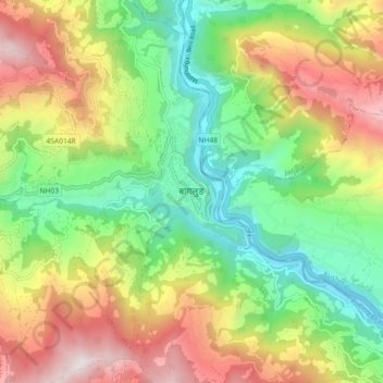
Naam: Topografische kaart Baglung, hoogte, reliëf.
Locatie: Baglung, Gandaki Province, Nepal (28.22511 83.56299 28.30511 83.64299)
Gemiddelde hoogte: 1.358 m
Minimale hoogte: 712 m
Maximale hoogte: 2.288 m
Doe een donatie
Rust jezelf uit voor je volgende avontuur:
Als Amazon-partner verdient deze site een commissie op in aanmerking komende aankopen, zonder extra kosten voor jou.
Andere topografische kaarten
Klik op een kaart om zijn topografie, zijn hoogte en zijn reliëf te bekijken.