
Topografische kaart Potomac River
Interactieve kaart
Klik op de kaart om de hoogte weer te geven.
Over deze kaart
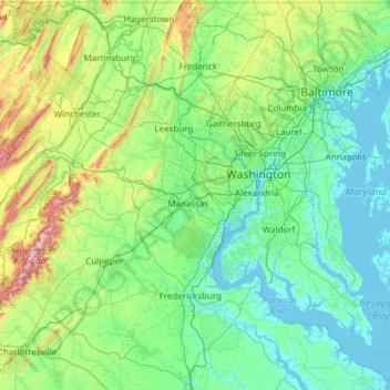
Naam: Topografische kaart Potomac River, hoogte, reliëf.
Gemiddelde hoogte: 143 m
Minimale hoogte: -5 m
Maximale hoogte: 1.207 m
Andere topografische kaarten
Klik op een kaart om zijn topografie, zijn hoogte en zijn reliëf te bekijken.
Chesapeake Bay
United States of America > Maryland
Chesapeake Bay, Dorchester County, Maryland, United States of America
Gemiddelde hoogte: 0 m
Upper Potomac River
United States of America > Maryland
Upper Potomac River, Washington County, Maryland, 25434, United States of America
Gemiddelde hoogte: 220 m
Lower Potomac River
United States of America > Maryland
Lower Potomac River, Charles County, Maryland, 20566, United States of America
Gemiddelde hoogte: 39 m
Williston Lake
United States of America > Maryland > Williston
Williston Lake, Williston Road, Williams Heights, Williston, Caroline County, Maryland, 21629, United States of America
Gemiddelde hoogte: 11 m
Auth Village
United States of America > Maryland > Auth Village
Auth Village, Camp Springs, Prince George's County, Maryland, 20746, United States of America
Gemiddelde hoogte: 77 m
Fairview
United States of America > Maryland > Fairview
Fairview, Burtonsville, Montgomery County, Maryland, 20866, United States of America
Gemiddelde hoogte: 135 m
East Riverdale
United States of America > Maryland > East Riverdale
East Riverdale, Prince George's County, Maryland, 20737, United States of America
Gemiddelde hoogte: 36 m
Wood Point
United States of America > Maryland > Wood Point
Wood Point, Washington County, Maryland, 21741, United States of America
Gemiddelde hoogte: 184 m
Gunpowder
United States of America > Maryland
Gunpowder, Joppatowne, Harford County, Maryland, 21085, United States of America
Gemiddelde hoogte: 38 m