
Topografische kaart Marmari
Interactieve kaart
Klik op de kaart om de hoogte weer te geven.
Over deze kaart
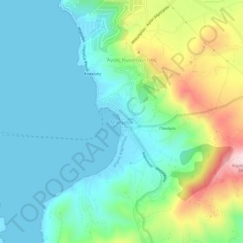
Naam: Topografische kaart Marmari, hoogte, reliëf.
Gemiddelde hoogte: 99 m
Minimale hoogte: 0 m
Maximale hoogte: 380 m
Andere topografische kaarten
Klik op een kaart om zijn topografie, zijn hoogte en zijn reliëf te bekijken.
Karystos
Greece > Thessaly and Central Greece > Euboea Regional Unit
Karystos, Karystos Municipality, Euboea Regional Unit, Central Greece, Thessaly and Central Greece, 340 01, Greece
Gemiddelde hoogte: 167 m
Κάτω Στενή
Greece > Thessaly and Central Greece > Euboea Regional Unit
Κάτω Στενή, Dirfyon - Messapion Municipality, Euboea Regional Unit, Central Greece, Thessaly and Central Greece, 340 14, Greece
Gemiddelde hoogte: 369 m
Αιδηψός
Greece > Thessaly and Central Greece > Euboea Regional Unit
Αιδηψός, Istiaia-Aidipsos Municipality, Euboea Regional Unit, Central Greece, Thessaly and Central Greece, 343 00, Greece
Gemiddelde hoogte: 113 m
Agios Ioannis
Greece > Thessaly and Central Greece > Euboea Regional Unit
Agios Ioannis, Kymi - Aliveri Anna Municipality, Euboea Regional Unit, Central Greece, Thessaly and Central Greece, 345 00, Greece
Gemiddelde hoogte: 129 m
Xirovrysi
Greece > Thessaly and Central Greece > Euboea Regional Unit > Municipal Unit of Anthidon
Xirovrysi, Municipal Unit of Anthidon, Municipality of Chalkida, Euboea Regional Unit, Central Greece, Thessaly and Central Greece, 341 31, Greece
Gemiddelde hoogte: 15 m
Skyros
Greece > Thessaly and Central Greece > Euboea Regional Unit
Skyros, Euboea Regional Unit, Central Greece, Thessaly and Central Greece, 340 07, Greece
Gemiddelde hoogte: 61 m
Chalkida
Greece > Thessaly and Central Greece > Euboea Regional Unit
Chalkida, Municipality of Chalkida, Euboea Regional Unit, Central Greece, Thessaly and Central Greece, 341 09, Greece
Gemiddelde hoogte: 129 m