
Topografische kaart Hartford
Interactieve kaart
Klik op de kaart om de hoogte weer te geven.
Over deze kaart
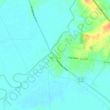
Naam: Topografische kaart Hartford, hoogte, reliëf.
Locatie: Hartford, Ohio County, Kentucky, United States (37.43446 -86.91460 37.46950 -86.87671)
Gemiddelde hoogte: 123 m
Minimale hoogte: 115 m
Maximale hoogte: 155 m
Several elements of the Downtown Hartford Historic District, including the courthouse, jail and main block of the Hartford City Hall, remain virtually intact on the exterior. As in most downtowns, however, storefronts have suffered the greatest changes. Fortunately, most of the upper elevations of these buildings have been well preserved so that the district's streetscape retains its historic character. Despite alterations, the district remains a visually distinct entity due to the extensively renovated older buildings and new construction that define its edges.
Andere topografische kaarten
Klik op een kaart om zijn topografie, zijn hoogte en zijn reliëf te bekijken.
No Creek
United States > Kentucky > Ohio County
No Creek, Ohio County, Kentucky, United States
Gemiddelde hoogte: 129 m
Olaton
United States > Kentucky > Ohio County
Olaton, Ohio County, Kentucky, 42361, United States
Gemiddelde hoogte: 157 m
Fordsville
United States > Kentucky > Ohio County > Fordsville
Fordsville, Ohio County, Kentucky, United States
Gemiddelde hoogte: 163 m