
Topografische kaart Western River (South Branch)
Interactieve kaart
Klik op de kaart om de hoogte weer te geven.
Over deze kaart
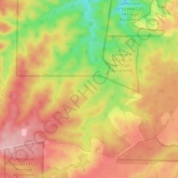
Naam: Topografische kaart Western River (South Branch), hoogte, reliëf.
Gemiddelde hoogte: 212 m
Minimale hoogte: 118 m
Maximale hoogte: 282 m
Andere topografische kaarten
Klik op een kaart om zijn topografie, zijn hoogte en zijn reliëf te bekijken.
Kangaroo Island
Australia > South Australia > Kangaroo Island Council
Kangaroo Island, Kangaroo Island Council, South Australia, Australia
Gemiddelde hoogte: 22 m
Whale Gully
Australia > South Australia > Kangaroo Island Council
Whale Gully, De Mole River, Kangaroo Island Council, South Australia, 5223, Australia
Gemiddelde hoogte: 49 m
Kingscote
Australia > South Australia > Kangaroo Island Council > Kingscote
Kingscote, Kangaroo Island Council, South Australia, 5223, Australia
Gemiddelde hoogte: 7 m