
Topografische kaart Santa Marta
Interactieve kaart
Klik op de kaart om de hoogte weer te geven.
Over deze kaart
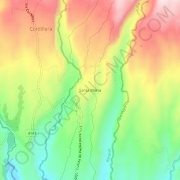
Naam: Topografische kaart Santa Marta, hoogte, reliëf.
Locatie: Santa Marta, Paraiso, Distrito Boquerón, Chiriquí, Panama (8.67471 -82.60876 8.71471 -82.56876)
Gemiddelde hoogte: 1.001 m
Minimale hoogte: 800 m
Maximale hoogte: 1.222 m