
Topografische kaart Bahamas
Interactieve kaart
Klik op de kaart om de hoogte weer te geven.
Over deze kaart
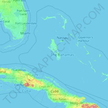
Naam: Topografische kaart Bahamas, hoogte, reliëf.
Locatie: Bahamas (20.70598 -80.70019 27.47346 -72.44775)
Gemiddelde hoogte: 9 m
Minimale hoogte: -4 m
Maximale hoogte: 1.111 m
According to the Köppen climate classification, the climate of The Bahamas is mostly tropical savannah climate or Aw, with a hot and wet season and a warm and dry season. The low latitude, warm tropical Gulf Stream, and low elevation give The Bahamas a warm and winterless climate.
Andere topografische kaarten
Klik op een kaart om zijn topografie, zijn hoogte en zijn reliëf te bekijken.
Great Stirrup Cay
Great Stirrup Cay, Berry Islands, Bahamas
Gemiddelde hoogte: 1 m
Skyline Heights
Skyline Heights, New Providence, Bahamas
Gemiddelde hoogte: 9 m
Marsh Harbour
Bahamas > Marsh Harbour > Marsh Harbour
Marsh Harbour, AB20087, Bahamas
Gemiddelde hoogte: 2 m