
Topografische kaart Cachuma Village
Interactieve kaart
Klik op de kaart om de hoogte weer te geven.
Over deze kaart
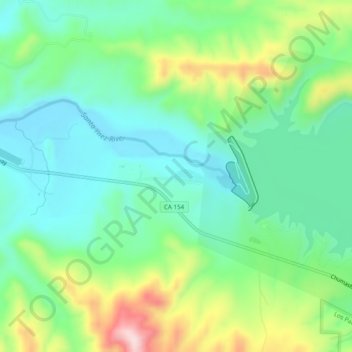
Naam: Topografische kaart Cachuma Village, hoogte, reliëf.
Locatie: Cachuma Village, Santa Barbara County, Californië, VS (34.56610 -120.01098 34.60610 -119.97098)
Gemiddelde hoogte: 262 m
Minimale hoogte: 163 m
Maximale hoogte: 486 m