
Topografische kaart City of Greater Dandenong
Interactieve kaart
Klik op de kaart om de hoogte weer te geven.
Over deze kaart
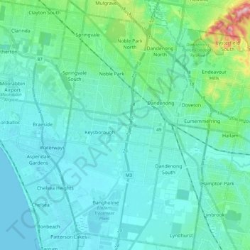
Naam: Topografische kaart City of Greater Dandenong, hoogte, reliëf.
Locatie: City of Greater Dandenong, Victoria, Australië (-38.07767 145.12966 -37.92456 145.25198)
Gemiddelde hoogte: 33 m
Minimale hoogte: -1 m
Maximale hoogte: 236 m
Andere topografische kaarten
Klik op een kaart om zijn topografie, zijn hoogte en zijn reliëf te bekijken.
The Pinnacle
The Pinnacle, Shire of Northern Grampians, Victoria, 3381, Australië
Gemiddelde hoogte: 471 m
Quambatook
Quambatook, Shire of Gannawarra, Victoria, 3540, Australië
Gemiddelde hoogte: 96 m
Surrey Hills
Surrey Hills, City of Boroondara, Victoria, Australië
Gemiddelde hoogte: 96 m
Mount Egerton
Australië > Victoria > Mount Egerton
Mount Egerton, Shire of Moorabool, Victoria, Australië
Gemiddelde hoogte: 546 m
Echo Point
Echo Point, Shire of Wellington, Victoria, Australië
Gemiddelde hoogte: 903 m
Don Valley
Australië > Victoria > Melbourne > Don Valley
Don Valley, Melbourne, Shire of Yarra Ranges, Victoria, Australië
Gemiddelde hoogte: 388 m
Seldom Seen
Australië > Victoria > Seldom Seen
Seldom Seen, Shire of East Gippsland, Gippsland, Victoria, Australië
Gemiddelde hoogte: 879 m
Healesville
Healesville, Shire of Yarra Ranges, Victoria, 3777, Australië
Gemiddelde hoogte: 501 m
Rural City of Wangaratta
Rural City of Wangaratta, Hume, Victoria, Australië
Gemiddelde hoogte: 435 m
Mount Murphy
Mount Murphy, Shire of East Gippsland, Gippsland, Victoria, Australië
Gemiddelde hoogte: 1.198 m
Mount Cassel
Mount Cassel, Rural City of Ararat, Grampians, Victoria, Australië
Gemiddelde hoogte: 465 m
Mount Sabine
Mount Sabine, Shire of Colac Otway, Barwon South West, Victoria, Australië
Gemiddelde hoogte: 481 m