
Topografische kaart Taos County
Interactieve kaart
Klik op de kaart om de hoogte weer te geven.
Over deze kaart
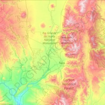
Naam: Topografische kaart Taos County, hoogte, reliëf.
Locatie: Taos County, Nieuw-Mexico, VS (36.01287 -106.05840 36.99597 -105.20011)
Gemiddelde hoogte: 2.561 m
Minimale hoogte: 1.709 m
Maximale hoogte: 3.980 m
Andere topografische kaarten
Klik op een kaart om zijn topografie, zijn hoogte en zijn reliëf te bekijken.
Puesta Del Sol
VS > Nieuw-Mexico > Puesta Del Sol
Puesta Del Sol, Sandoval County, Nieuw-Mexico, 87043, VS
Gemiddelde hoogte: 1.807 m
Chaco Culture National Historical Park
Chaco Culture National Historical Park, Chaco Loop Road, San Juan County, Nieuw-Mexico, VS
Gemiddelde hoogte: 1.919 m
Santa Fe
VS > Nieuw-Mexico > Santa Fe
Santa Fe, Santa Fe County, Nieuw-Mexico, VS
Gemiddelde hoogte: 2.222 m
Los Alamos
VS > Nieuw-Mexico > Los Alamos
Los Alamos, Los Alamos County, Nieuw-Mexico, VS
Gemiddelde hoogte: 2.231 m
Rio Grande
VS > Nieuw-Mexico > La Joya
Rio Grande, Del Rio Camino, La Joya, Socorro County, Nieuw-Mexico, 87028-9998, VS
Gemiddelde hoogte: 1.502 m