
Topografische kaart Yarra River
Interactieve kaart
Klik op de kaart om de hoogte weer te geven.
Over deze kaart
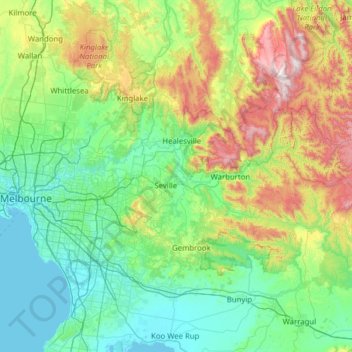
Naam: Topografische kaart Yarra River, hoogte, reliëf.
Locatie: Yarra River, Victoria, 3005, Australia (-37.84612 144.89700 -37.65759 146.14574)
Gemiddelde hoogte: 308 m
Minimale hoogte: -1 m
Maximale hoogte: 1.466 m
Andere topografische kaarten
Klik op een kaart om zijn topografie, zijn hoogte en zijn reliëf te bekijken.
Lake Glenmaggie
Lake Glenmaggie, Glenmaggie, Shire of Wellington, Victoria, Australia
Gemiddelde hoogte: 98 m
Yarra Ranges National Park
Australia > Victoria > Melbourne
Yarra Ranges National Park, Reefton, Melbourne, Shire of Yarra Ranges, Victoria, Australia
Gemiddelde hoogte: 465 m
Phillip Island
Australia > Victoria > Ventnor
Phillip Island, Ventnor, Bass Coast Shire, Victoria, Australia
Gemiddelde hoogte: 5 m
Melbourne District
Australia > Victoria > Melbourne
Melbourne District, Melbourne, City of Melbourne, Victoria, Australia
Gemiddelde hoogte: 20 m
Grampians National Park
Grampians National Park, Bellfield, Shire of Northern Grampians, Victoria, Australia
Gemiddelde hoogte: 262 m
Mount Eliza
Australia > Victoria > Melbourne
Mount Eliza, Melbourne, Shire of Mornington Peninsula, Victoria, 3930, Australia
Gemiddelde hoogte: 60 m
Glen Waverley
Glen Waverley, City of Monash, Victoria, 3150, Australia
Gemiddelde hoogte: 103 m
Mornington District
Australia > Victoria > Melbourne
Mornington District, Melbourne, Shire of Mornington Peninsula, Victoria, Australia
Gemiddelde hoogte: 50 m
Castlemaine
Castlemaine, Shire of Mount Alexander, Victoria, 3450, Australia
Gemiddelde hoogte: 319 m
Mount Martha
Australia > Victoria > Melbourne
Mount Martha, Melbourne, Shire of Mornington Peninsula, Victoria, 3934, Australia
Gemiddelde hoogte: 40 m
Division of Kooyong
Australia > Victoria > Melbourne
Division of Kooyong, Melbourne, City of Boroondara, Victoria, Australia
Gemiddelde hoogte: 55 m
Kingsville
Australia > Victoria > Melbourne
Kingsville, Melbourne, City of Maribyrnong, Victoria, 3012, Australia
Gemiddelde hoogte: 23 m
Wilsons Promontory National Park
Wilsons Promontory National Park, Victoria, Australia
Gemiddelde hoogte: 32 m
Eltham District
Australia > Victoria > Greensborough
Eltham District, Greensborough, City of Banyule, Victoria, Australia
Gemiddelde hoogte: 85 m
Ocean Grove
Australia > Victoria > Ocean Grove
Ocean Grove, City of Greater Geelong, Victoria, 3226, Australia
Gemiddelde hoogte: 16 m
Warrnambool
Warrnambool, City of Warrnambool, Victoria, 3280, Australia
Gemiddelde hoogte: 19 m
Shepparton District
Australia > Victoria > Shepparton
Shepparton District, Currawa Rise, Dookie, Shepparton, City of Greater Shepparton, Hume, Victoria, 3630, Australia
Gemiddelde hoogte: 113 m
Great Otway National Park
Great Otway National Park, Victoria, Australia
Gemiddelde hoogte: 91 m
Bells Beach
Bells Beach, Surf Coast Shire, Victoria, 3228, Australia
Gemiddelde hoogte: 55 m
Merricks North
Australia > Victoria > Melbourne
Merricks North, Melbourne, Shire of Mornington Peninsula, Victoria, 3926, Australia
Gemiddelde hoogte: 100 m
Eurobin Streamside Reserve
Eurobin Streamside Reserve, Great Alpine Road, Eurobin, Ovens, Alpine Shire, Victoria, 3739, Australia
Gemiddelde hoogte: 304 m
Yackandandah
Australia > Victoria > Yackandandah
Yackandandah, Shire of Indigo, Hume, Victoria, 3749, Australia
Gemiddelde hoogte: 500 m
Yarra Valley
Australia > Victoria > Melbourne
Yarra Valley, Melbourne, Shire of Yarra Ranges, Victoria, Australia
Gemiddelde hoogte: 305 m
Mckenzie Hill
Mckenzie Hill, Shire of Mount Alexander, Victoria, 3451, Australia
Gemiddelde hoogte: 308 m