
Topografische kaart Town of Kentville
Interactieve kaart
Klik op de kaart om de hoogte weer te geven.
Over deze kaart
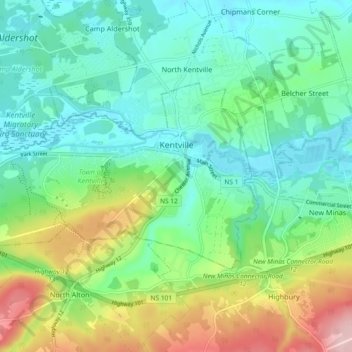
Naam: Topografische kaart Town of Kentville, hoogte, reliëf.
Gemiddelde hoogte: 64 m
Minimale hoogte: 1 m
Maximale hoogte: 216 m
Andere topografische kaarten
Klik op een kaart om zijn topografie, zijn hoogte en zijn reliëf te bekijken.
Kings County
Canada > Nova Scotia > Kings County
Kings County, Nova Scotia, Canada
Gemiddelde hoogte: 109 m
Town of Berwick
Canada > Nova Scotia > Kings County
Town of Berwick, Kings County, Nova Scotia, Canada
Gemiddelde hoogte: 37 m
Cloud Lake
Canada > Nova Scotia > Kings County > Cloud Lake
Cloud Lake, Municipality of the County of Kings, Kings County, Nova Scotia, Canada
Gemiddelde hoogte: 200 m
Berwick
Canada > Nova Scotia > Kings County > Berwick
Berwick, Town of Berwick, Kings County, Nova Scotia, Canada
Gemiddelde hoogte: 37 m
Kentville
Canada > Nova Scotia > Kings County > Kentville
Kentville, Town of Kentville, Kings County, Nova Scotia, B4N 4S4, Canada
Gemiddelde hoogte: 64 m
Canaan
Canada > Nova Scotia > Kings County > Canaan
Canaan, Municipality of the County of Kings, Kings County, Nova Scotia, Canada
Gemiddelde hoogte: 176 m
Halls Harbour
Canada > Nova Scotia > Kings County > Halls Harbour
Halls Harbour, Municipality of the County of Kings, Kings County, Nova Scotia, Canada
Gemiddelde hoogte: 79 m