Geolokaliseren

Topografische kaart Tahua

Interactieve kaart

Klik op de kaart om de hoogte weer te geven.

Over deze kaart

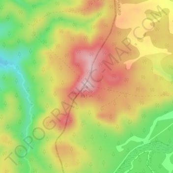
Naam: Topografische kaart Tahua, hoogte, reliëf.

Locatie: Tahua, Taupō District, Waikato, Nieuw-Zeeland (-38.94696 175.56007 -38.94686 175.56017)

Gemiddelde hoogte: 671 m

Minimale hoogte: 537 m

Maximale hoogte: 792 m

Andere topografische kaarten

Klik op een kaart om zijn topografie, zijn hoogte en zijn reliëf te bekijken.

Mount Ngāuruhoe

Nieuw-Zeeland > Waikato > Taupō District

Mount Ngāuruhoe, Taupō District, Waikato, Nieuw-Zeeland

Gemiddelde hoogte: 1.725 m

The Pinnacles

Nieuw-Zeeland > Waikato

The Pinnacles, Waikato, Nieuw-Zeeland

Gemiddelde hoogte: 14 m

Waitomo Cave

Nieuw-Zeeland > Waikato > Waitomo District > Waitomo Caves

Waitomo Cave, Waitomo Walkway, Waitomo Caves, Waitomo District, Waikato, 3981, Nieuw-Zeeland

Gemiddelde hoogte: 98 m

Raglan

Nieuw-Zeeland > Waikato > Waikato District

Raglan, Waikato District, Waikato, 3225, Nieuw-Zeeland

Gemiddelde hoogte: 41 m

Hamilton

Nieuw-Zeeland > Waikato > Hamilton

Hamilton, Hamilton City, Waikato, 3204, Nieuw-Zeeland

Gemiddelde hoogte: 53 m

Noordereiland

Nieuw-Zeeland > Waikato

Noordereiland, South Waikato District, Waikato, Nieuw-Zeeland

Gemiddelde hoogte: 66 m