
Topografische kaart Dent Blanche
Interactieve kaart
Klik op de kaart om de hoogte weer te geven.
Over deze kaart
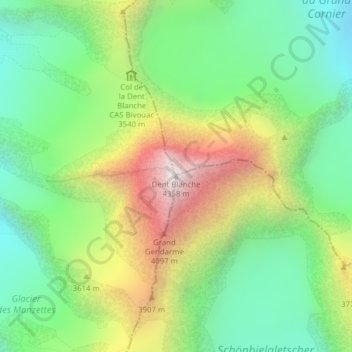
Naam: Topografische kaart Dent Blanche, hoogte, reliëf.
Locatie: Dent Blanche, Evolène, Hérens, Valais/Wallis, 1983, Zwitserland (46.03413 7.61188 46.03423 7.61198)
Gemiddelde hoogte: 3.458 m
Minimale hoogte: 2.923 m
Maximale hoogte: 4.350 m