
Topografische kaart Isle Royale
Interactieve kaart
Klik op de kaart om de hoogte weer te geven.
Over deze kaart
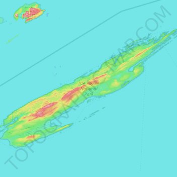
Naam: Topografische kaart Isle Royale, hoogte, reliëf.
Locatie: Isle Royale, Keweenaw County, Michigan, United States (47.82376 -89.23555 48.19102 -88.42232)
Gemiddelde hoogte: 190 m
Minimale hoogte: 176 m
Maximale hoogte: 443 m
According to the Köppen climate classification system, Isle Royale National Park has a mild summer Humid continental climate (Dfb). According to the United States Department of Agriculture, the Plant Hardiness zone is 4b at 1178 ft (359 m) elevation with an average annual extreme minimum temperature of -24.2 °F (-31.2 °C).
Andere topografische kaarten
Klik op een kaart om zijn topografie, zijn hoogte en zijn reliëf te bekijken.
Eagle Harbor Township
United States > Michigan > Keweenaw County
Eagle Harbor Township, Keweenaw County, Michigan, United States
Gemiddelde hoogte: 190 m
Mohawk
United States > Michigan > Keweenaw County
Mohawk, Allouez Township, Keweenaw County, Michigan, 49901, United States
Gemiddelde hoogte: 300 m
Eagle Harbor
United States > Michigan > Keweenaw County
Eagle Harbor, Eagle Harbor Township, Keweenaw County, Michigan, United States
Gemiddelde hoogte: 200 m
Allouez
United States > Michigan > Keweenaw County
Allouez, Allouez Township, Keweenaw County, Michigan, 49805, United States
Gemiddelde hoogte: 301 m
Isle Royale National Park
United States > Michigan > Keweenaw County
Isle Royale National Park, Keweenaw County, Michigan, United States
Gemiddelde hoogte: 189 m
Gay
United States > Michigan > Keweenaw County > Gay
Gay, Sherman Township, Keweenaw County, Michigan, United States
Gemiddelde hoogte: 188 m
Copper Harbor
United States > Michigan > Keweenaw County
Copper Harbor, Grant Township, Keweenaw County, Michigan, 49918, United States
Gemiddelde hoogte: 220 m