
Topografische kaart Istanbul
Interactieve kaart
Klik op de kaart om de hoogte weer te geven.
Over deze kaart
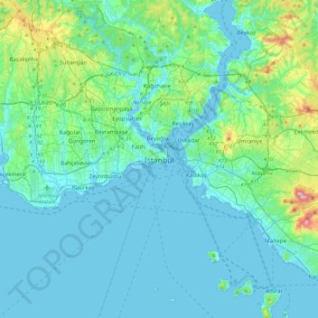
Naam: Topografische kaart Istanbul, hoogte, reliëf.
Locatie: Istanbul, Fatih, Istanbul, Marmara Region, 34122, Turkey (40.84638 28.81587 41.16638 29.13587)
Gemiddelde hoogte: 57 m
Minimale hoogte: -2 m
Maximale hoogte: 429 m
Following the model of Rome, the historic peninsula is said to be characterized by seven hills, each topped by imperial mosques. The easternmost of these hills is the site of Topkapı Palace on the Sarayburnu. Rising from the opposite side of the Golden Horn is another, conical hill, where the modern Beyoğlu district is. Because of the topography, buildings in Beyoğlu were once constructed with the help of terraced retaining walls, and roads were laid out in the form of steps. Üsküdar on the Asian side exhibits similarly hilly characteristics, with the terrain gradually extending down to the Bosphorus coast, but the landscape in Şemsipaşa and Ayazma is more abrupt, akin to a promontory. The highest point in Istanbul is Çamlıca Hill, with an altitude of 288 meters (945 ft). The northern half of Istanbul has a higher mean elevation compared to the south coast, with locations surpassing 200 meters (660 ft), and some coasts with steep cliffs resembling fjords, especially around the northern end of the Bosphorus, where it opens up to the Black Sea.
Andere topografische kaarten
Klik op een kaart om zijn topografie, zijn hoogte en zijn reliëf te bekijken.