
Topografische kaart Ankara
Interactieve kaart
Klik op de kaart om de hoogte weer te geven.
Over deze kaart
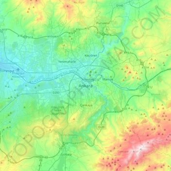
Naam: Topografische kaart Ankara, hoogte, reliëf.
Gemiddelde hoogte: 1.082 m
Minimale hoogte: 798 m
Maximale hoogte: 1.864 m
Ankara has a cold semi-arid climate (Köppen climate classification: BSk). Under the Trewartha climate classification, Ankara has a temperate humid continental climate (Dc). Due to its elevation and inland location, Ankara has cold and snowy winters, and hot and dry summers. Rainfall occurs mostly during the spring and autumn. The city lies in USDA Hardiness zone 7b, and its annual average precipitation is fairly low at 414 millimeters (16 in), nevertheless precipitation can be observed throughout the year. Monthly mean temperatures range from 0.9 °C (33.6 °F) in January to 24.3 °C (75.7 °F) in July, with an annual mean of 12.6 °C (54.7 °F).