
Topografische kaart Teton County
Interactieve kaart
Klik op de kaart om de hoogte weer te geven.
Over deze kaart
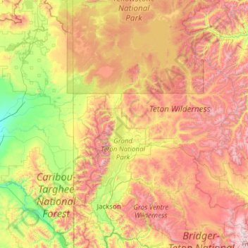
Naam: Topografische kaart Teton County, hoogte, reliëf.
Locatie: Teton County, Wyoming, VS (43.23499 -111.05533 44.66681 -110.05103)
Gemiddelde hoogte: 2.400 m
Minimale hoogte: 1.519 m
Maximale hoogte: 4.043 m
Andere topografische kaarten
Klik op een kaart om zijn topografie, zijn hoogte en zijn reliëf te bekijken.
Yellowstone National Park
Yellowstone National Park, Mary Mountain-Nez Perce, Teton County, Wyoming, VS
Gemiddelde hoogte: 2.450 m
Rock Springs
VS > Wyoming > Rock Springs
Rock Springs, Sweetwater County, Wyoming, 82901, VS
Gemiddelde hoogte: 2.011 m
Grand Teton National Park
Grand Teton National Park, Teton Park Road, Teton County, Wyoming, 83013, VS
Gemiddelde hoogte: 2.409 m