
Topografische kaart North Cascades National Park
Interactieve kaart
Klik op de kaart om de hoogte weer te geven.
Over deze kaart
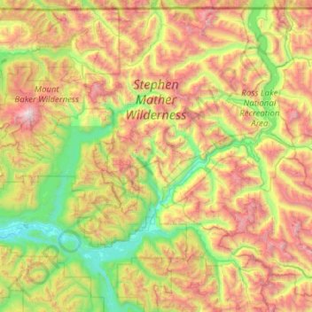
Naam: Topografische kaart North Cascades National Park, hoogte, reliëf.
Gemiddelde hoogte: 1.151 m
Minimale hoogte: 32 m
Maximale hoogte: 3.265 m
Andere topografische kaarten
Klik op een kaart om zijn topografie, zijn hoogte en zijn reliëf te bekijken.
Mount Saint Helens
VS > Washington
Mount Saint Helens, Skamania County, Washington, VS
Gemiddelde hoogte: 2.108 m
Mount Vernon
VS > Washington > Mount Vernon
Mount Vernon, Skagit County, Washington, VS
Gemiddelde hoogte: 37 m
Maple Valley
VS > Washington > Maple Valley
Maple Valley, King County, Washington, 98038, VS
Gemiddelde hoogte: 160 m
First Hill
VS > Washington > Mercer Island
First Hill, Mercer Island, King County, Washington, 98040, VS
Gemiddelde hoogte: 31 m