
Topografische kaart Thornton Rust
Interactieve kaart
Klik op de kaart om de hoogte weer te geven.
Over deze kaart
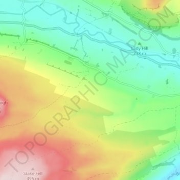
Naam: Topografische kaart Thornton Rust, hoogte, reliëf.
Locatie: Thornton Rust, North Yorkshire, England, United Kingdom (54.27553 -2.08262 54.30493 -2.01118)
Gemiddelde hoogte: 299 m
Minimale hoogte: 170 m
Maximale hoogte: 502 m
The village is at an elevation of 870 feet (270 m) at its highest. The River Ure and the A684 are 0.5 miles (0.8 km) to the north. The village of Aysgarth is 2.5 miles (4 km) to the south-east and Bainbridge 2.6 miles (4.2 km) to the north-west. It is a typical linear village on top of a limestone scar.[6]
Andere topografische kaarten
Klik op een kaart om zijn topografie, zijn hoogte en zijn reliëf te bekijken.
North York Moors National Park
United Kingdom > England > North Yorkshire
North York Moors National Park, North Yorkshire, Tees Valley, England, United Kingdom
Gemiddelde hoogte: 110 m
Harrogate
United Kingdom > England > North Yorkshire
Harrogate, North Yorkshire, England, United Kingdom
Gemiddelde hoogte: 131 m
Carlton Husthwaite
United Kingdom > England > North Yorkshire
Carlton Husthwaite, North Yorkshire, England, United Kingdom
Gemiddelde hoogte: 54 m
Finghall
United Kingdom > England > North Yorkshire
Finghall, North Yorkshire, England, DL8 5NB, United Kingdom
Gemiddelde hoogte: 126 m
Calcutt
United Kingdom > England > North Yorkshire > Knaresborough
Calcutt, Knaresborough, North Yorkshire, England, HG5 8JF, United Kingdom
Gemiddelde hoogte: 62 m
East Rounton
United Kingdom > England > North Yorkshire
East Rounton, North Yorkshire, England, United Kingdom
Gemiddelde hoogte: 65 m
Selby
United Kingdom > England > North Yorkshire
Selby, North Yorkshire, England, United Kingdom
Gemiddelde hoogte: 7 m
Husthwaite
United Kingdom > England > North Yorkshire
Husthwaite, North Yorkshire, England, United Kingdom
Gemiddelde hoogte: 58 m
Draughton
United Kingdom > England > North Yorkshire
Draughton, North Yorkshire, England, BD23 6EA, United Kingdom
Gemiddelde hoogte: 221 m
Embsay Reservoir
United Kingdom > England > North Yorkshire > Embsay
Embsay Reservoir, Embsay with Eastby, Embsay, North Yorkshire, England, United Kingdom
Gemiddelde hoogte: 250 m
Yedingham
United Kingdom > England > North Yorkshire
Yedingham, North Yorkshire, England, YO17 8SN, United Kingdom
Gemiddelde hoogte: 22 m
West Knapton
United Kingdom > England > North Yorkshire > Knapton
West Knapton, Scampston, Knapton, North Yorkshire, England, YO17 8JB, United Kingdom
Gemiddelde hoogte: 46 m
Scarborough
United Kingdom > England > North Yorkshire
Scarborough, North Yorkshire, England, United Kingdom
Gemiddelde hoogte: 50 m
Embsay
United Kingdom > England > North Yorkshire
Embsay, Carleton-in-Craven, North Yorkshire, England, BD23 6RS, United Kingdom
Gemiddelde hoogte: 219 m
Swinton
United Kingdom > England > North Yorkshire
Swinton, North Yorkshire, England, YO17 6SS, United Kingdom
Gemiddelde hoogte: 46 m
Crummackdale
United Kingdom > England > North Yorkshire > Austwick
Crummackdale, Austwick, North Yorkshire, England, United Kingdom
Gemiddelde hoogte: 275 m
Sinnington
United Kingdom > England > North Yorkshire
Sinnington, North Yorkshire, England, YO62 6RZ, United Kingdom
Gemiddelde hoogte: 66 m
Warsill
United Kingdom > England > North Yorkshire
Warsill, North Yorkshire, England, United Kingdom
Gemiddelde hoogte: 211 m
Tholthorpe
United Kingdom > England > North Yorkshire > Tholthorpe
Tholthorpe, North Yorkshire, England, United Kingdom
Gemiddelde hoogte: 19 m
Feizor
United Kingdom > England > North Yorkshire > Lawkland
Feizor, Austwick, Lawkland, North Yorkshire, England, LA2 8DF, United Kingdom
Gemiddelde hoogte: 227 m
Whenby
United Kingdom > England > North Yorkshire
Whenby, North Yorkshire, England, United Kingdom
Gemiddelde hoogte: 55 m
Hutton Buscel
United Kingdom > England > North Yorkshire
Hutton Buscel, North Yorkshire, England, YO13 9LN, United Kingdom
Gemiddelde hoogte: 60 m
Burnsall
United Kingdom > England > North Yorkshire
Burnsall, North Yorkshire, England, United Kingdom
Gemiddelde hoogte: 253 m
Burnt Yates
United Kingdom > England > North Yorkshire
Burnt Yates, Clint cum Hamlets, North Yorkshire, England, HG3 3HQ, United Kingdom
Gemiddelde hoogte: 117 m
Helperby
United Kingdom > England > North Yorkshire
Helperby, North Yorkshire, England, YO61 2PJ, United Kingdom
Gemiddelde hoogte: 18 m
Cawton
United Kingdom > England > North Yorkshire
Cawton, North Yorkshire, England, United Kingdom
Gemiddelde hoogte: 58 m
Sharow
United Kingdom > England > North Yorkshire
Sharow, North Yorkshire, England, United Kingdom
Gemiddelde hoogte: 38 m
Marton-cum-Grafton
United Kingdom > England > North Yorkshire
Marton-cum-Grafton, North Yorkshire, England, YO51 9QY, United Kingdom
Gemiddelde hoogte: 43 m
Greenhow Hill
United Kingdom > England > North Yorkshire
Greenhow Hill, Bewerley, North Yorkshire, England, HG3 5JH, United Kingdom
Gemiddelde hoogte: 358 m
South Duffield
United Kingdom > England > North Yorkshire
South Duffield, Cliffe, North Yorkshire, England, YO8 6TE, United Kingdom
Gemiddelde hoogte: 6 m
Easby
United Kingdom > England > North Yorkshire
Easby, North Yorkshire, England, United Kingdom
Gemiddelde hoogte: 132 m
Sand Hutton
United Kingdom > England > North Yorkshire
Sand Hutton, North Yorkshire, England, United Kingdom
Gemiddelde hoogte: 29 m
Scrayingham
United Kingdom > England > North Yorkshire
Scrayingham, North Yorkshire, England, YO41 1JD, United Kingdom
Gemiddelde hoogte: 27 m
Walburn Hall
United Kingdom > England > North Yorkshire
Walburn Hall, Walburn, North Yorkshire, England, DL11 6AF, United Kingdom
Gemiddelde hoogte: 257 m
East Ness
United Kingdom > England > North Yorkshire > Nunnington
East Ness, Nunnington, North Yorkshire, England, YO62 5XD, United Kingdom
Gemiddelde hoogte: 32 m
Azerley
United Kingdom > England > North Yorkshire
Azerley, North Yorkshire, England, United Kingdom
Gemiddelde hoogte: 107 m
Thixendale
United Kingdom > England > North Yorkshire
Thixendale, North Yorkshire, England, YO17 9TG, United Kingdom
Gemiddelde hoogte: 186 m
Cod Beck
United Kingdom > England > North Yorkshire > Osmotherley > Clack
Cod Beck, Clack, Osmotherley, North Yorkshire, England, United Kingdom
Gemiddelde hoogte: 156 m
Whitley
United Kingdom > England > North Yorkshire
Whitley, North Yorkshire, England, United Kingdom
Gemiddelde hoogte: 10 m
Brompton
United Kingdom > England > North Yorkshire
Brompton, North Yorkshire, England, United Kingdom
Gemiddelde hoogte: 60 m
Newton-on-Ouse
United Kingdom > England > North Yorkshire
Newton-on-Ouse, North Yorkshire, England, United Kingdom
Gemiddelde hoogte: 15 m
Kirby Wiske
United Kingdom > England > North Yorkshire
Kirby Wiske, North Yorkshire, England, United Kingdom
Gemiddelde hoogte: 27 m
Cracoe
United Kingdom > England > North Yorkshire
Cracoe, North Yorkshire, England, BD23 6LA, United Kingdom
Gemiddelde hoogte: 260 m
Long Drax
United Kingdom > England > North Yorkshire
Long Drax, North Yorkshire, England, United Kingdom
Gemiddelde hoogte: 5 m
Burythorpe
United Kingdom > England > North Yorkshire
Burythorpe, North Yorkshire, England, United Kingdom
Gemiddelde hoogte: 62 m
Little Fenton
United Kingdom > England > North Yorkshire
Little Fenton, North Yorkshire, England, LS25 6HF, United Kingdom
Gemiddelde hoogte: 8 m
Kirkdale
United Kingdom > England > North Yorkshire > Kirkbymoorside
Kirkdale, Kirkbymoorside, North Yorkshire, England, United Kingdom
Gemiddelde hoogte: 112 m
Scarborough
United Kingdom > England > North Yorkshire
Scarborough, North Yorkshire, England, YO11 1LP, United Kingdom
Gemiddelde hoogte: 39 m
Bradleys Both
United Kingdom > England > North Yorkshire
Bradleys Both, Low Snaygill, North Yorkshire, England, United Kingdom
Gemiddelde hoogte: 187 m
Raskelf
United Kingdom > England > North Yorkshire
Raskelf, North Yorkshire, England, United Kingdom
Gemiddelde hoogte: 25 m