
Topografische kaart Frankston
Interactieve kaart
Klik op de kaart om de hoogte weer te geven.
Over deze kaart
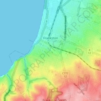
Naam: Topografische kaart Frankston, hoogte, reliëf.
Gemiddelde hoogte: 40 m
Minimale hoogte: 0 m
Maximale hoogte: 117 m
Olivers Hill is the most prominent elevation in Frankston which rises to 55 metres above sea level (180 feet) at its highest point in the suburb. Its origins date to approximately 415 to 360 million years ago. Its base is Mount Eliza Granite dating from the Devonian period, which was covered in lava tuffs in the Paleogene period. During the Miocene epoch in the Neogene period, the Frankston area was entirely flooded by the sea resulting in a mix of Balcombe Clay (at deep levels) and Baxter Sandstone (at shallow levels) covering the basaltic (lava) level. Fluctuating ice ages of the Pleistocene epoch in the current Quaternary period caused sea levels to rise and fall dramatically and for sedimentary rock and sand to be deposited on the surface of the hill. Aeolian processes in the current Holocene epoch, in which Port Phillip has periodically dried up (as recently as 1000 years ago), has caused further sand to be deposited.
Andere topografische kaarten
Klik op een kaart om zijn topografie, zijn hoogte en zijn reliëf te bekijken.
Yarra Ranges National Park
Australia > Victoria > Melbourne
Yarra Ranges National Park, Reefton, Melbourne, Shire of Yarra Ranges, Victoria, Australia
Gemiddelde hoogte: 465 m
Mount Eliza
Australia > Victoria > Melbourne
Mount Eliza, Melbourne, Shire of Mornington Peninsula, Victoria, 3930, Australia
Gemiddelde hoogte: 60 m
Mount Martha
Australia > Victoria > Melbourne
Mount Martha, Melbourne, Shire of Mornington Peninsula, Victoria, 3934, Australia
Gemiddelde hoogte: 40 m
Mornington District
Australia > Victoria > Melbourne
Mornington District, Melbourne, Shire of Mornington Peninsula, Victoria, Australia
Gemiddelde hoogte: 50 m
Melbourne District
Australia > Victoria > Melbourne
Melbourne District, Melbourne, City of Melbourne, Victoria, Australia
Gemiddelde hoogte: 20 m
Yarra Valley
Australia > Victoria > Melbourne
Yarra Valley, Melbourne, Shire of Yarra Ranges, Victoria, Australia
Gemiddelde hoogte: 305 m
Division of Kooyong
Australia > Victoria > Melbourne
Division of Kooyong, Melbourne, City of Boroondara, Victoria, Australia
Gemiddelde hoogte: 55 m
Kingsville
Australia > Victoria > Melbourne
Kingsville, Melbourne, City of Maribyrnong, Victoria, 3012, Australia
Gemiddelde hoogte: 23 m
Merricks North
Australia > Victoria > Melbourne
Merricks North, Melbourne, Shire of Mornington Peninsula, Victoria, 3926, Australia
Gemiddelde hoogte: 100 m
Mount Dandenong
Australia > Victoria > Melbourne
Mount Dandenong, Melbourne, Shire of Yarra Ranges, Victoria, 3767, Australia
Gemiddelde hoogte: 395 m
Point Cook
Australia > Victoria > Melbourne
Point Cook, Melbourne, City of Wyndham, Victoria, 3030, Australia
Gemiddelde hoogte: 8 m
RMIT A'Beckett Urban Square
Australia > Victoria > Melbourne
RMIT A'Beckett Urban Square, Melbourne, City of Melbourne, Victoria, 3000, Australia
Gemiddelde hoogte: 31 m
Ivanhoe East
Australia > Victoria > Melbourne
Ivanhoe East, Melbourne, City of Banyule, Victoria, 3079, Australia
Gemiddelde hoogte: 32 m
Carlton North
Australia > Victoria > Melbourne
Carlton North, Melbourne, City of Yarra, Victoria, 3054, Australia
Gemiddelde hoogte: 41 m
St Kilda East
Australia > Victoria > Melbourne
St Kilda East, Melbourne, City of Glen Eira, Victoria, 3183, Australia
Gemiddelde hoogte: 27 m
Doncaster East
Australia > Victoria > Melbourne
Doncaster East, Melbourne, City of Manningham, Victoria, 3109, Australia
Gemiddelde hoogte: 89 m
Northcote District
Australia > Victoria > Melbourne
Northcote District, Melbourne, City of Darebin, Victoria, Australia
Gemiddelde hoogte: 44 m
Gladysdale
Australia > Victoria > Melbourne
Gladysdale, Melbourne, Shire of Yarra Ranges, Victoria, 3797, Australia
Gemiddelde hoogte: 272 m
Bundoora District
Australia > Victoria > Melbourne
Bundoora District, Melbourne, City of Banyule, Victoria, Australia
Gemiddelde hoogte: 94 m
Endeavour Hills
Australia > Victoria > Melbourne
Endeavour Hills, Melbourne, City of Casey, Victoria, 3802, Australia
Gemiddelde hoogte: 68 m
Camberwell
Australia > Victoria > Melbourne
Camberwell, Melbourne, City of Boroondara, Victoria, 3124, Australia
Gemiddelde hoogte: 66 m
Box Hill District
Australia > Victoria > Melbourne > Blackburn
Box Hill District, Guildford Road, Surrey Hills, City of Boroondara, Victoria, 3127, Australia
Gemiddelde hoogte: 88 m
Kilsyth South
Australia > Victoria > Melbourne
Kilsyth South, Melbourne, City of Maroondah, Victoria, 3137, Australia
Gemiddelde hoogte: 133 m
Langwarrin
Australia > Victoria > Melbourne
Langwarrin, Melbourne, City of Frankston, Victoria, 3910, Australia
Gemiddelde hoogte: 71 m
South Melbourne
Australia > Victoria > Melbourne
South Melbourne, Melbourne, City of Port Phillip, Victoria, 3205, Australia
Gemiddelde hoogte: 9 m
Maribyrnong
Australia > Victoria > Melbourne
Maribyrnong, Melbourne, City of Maribyrnong, Victoria, 3032, Australia
Gemiddelde hoogte: 23 m
Mount Evelyn
Australia > Victoria > Melbourne
Mount Evelyn, Melbourne, Shire of Yarra Ranges, Victoria, 3796, Australia
Gemiddelde hoogte: 189 m
Melbourne Airport
Australia > Victoria > Melbourne
Melbourne Airport, Melbourne, City of Hume, Victoria, 3045, Australia
Gemiddelde hoogte: 105 m
Burwood East
Australia > Victoria > Melbourne
Burwood East, Melbourne, City of Whitehorse, Victoria, 3151, Australia
Gemiddelde hoogte: 117 m