Geolokaliseren

Topografische kaart Canyon de Chelly National Monument

Interactieve kaart

Klik op de kaart om de hoogte weer te geven.

Over deze kaart

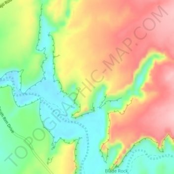
Naam: Topografische kaart Canyon de Chelly National Monument, hoogte, reliëf.

Locatie: Canyon de Chelly National Monument, Apache County, Arizona, VS (36.15523 -109.50905 36.15533 -109.50895)

Gemiddelde hoogte: 1.770 m

Minimale hoogte: 1.691 m

Maximale hoogte: 1.854 m

Andere topografische kaarten

Klik op een kaart om zijn topografie, zijn hoogte en zijn reliëf te bekijken.

Saguaro National Park

VS > Arizona

Saguaro National Park, Quilter Trail, Pima County, Arizona, VS

Gemiddelde hoogte: 1.174 m

Bagdad

VS > Arizona > Bagdad

Bagdad, Manzanita Court, Bagdad, Yavapai County, Arizona, 86321, VS

Gemiddelde hoogte: 1.181 m

Yuma

VS > Arizona > Yuma

Yuma, Yuma County, Arizona, 85364, VS

Gemiddelde hoogte: 69 m

Humphreys Peak

VS > Arizona

Humphreys Peak, Coconino County, Arizona, VS

Gemiddelde hoogte: 3.413 m

Flagstaff

VS > Arizona > Flagstaff

Flagstaff, Coconino County, Arizona, VS

Gemiddelde hoogte: 2.176 m

Cuates Butte

VS > Arizona

Cuates Butte, Santa Cruz County, Arizona, 85628, VS

Gemiddelde hoogte: 1.132 m

King Peak

VS > Arizona

King Peak, Yavapai County, Arizona, VS

Gemiddelde hoogte: 1.179 m

Mesa

VS > Arizona > Mesa

Mesa, Maricopa County, Arizona, VS

Gemiddelde hoogte: 385 m

Eloy

VS > Arizona > Eloy

Eloy, Pinal County, Arizona, 85131, VS

Gemiddelde hoogte: 478 m

Petrified Forest National Park

VS > Arizona

Petrified Forest National Park, Apache County, Arizona, 86028, VS

Gemiddelde hoogte: 1.722 m