
Topografische kaart Dohan
Interactieve kaart
Klik op de kaart om de hoogte weer te geven.
Over deze kaart
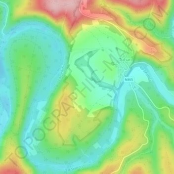
Naam: Topografische kaart Dohan, hoogte, reliëf.
Locatie: Dohan, Bouillon, Neufchâteau, Luxemburg, Wallonië, België (49.77870 5.11528 49.80675 5.16091)
Gemiddelde hoogte: 284 m
Minimale hoogte: 220 m
Maximale hoogte: 400 m
Andere topografische kaarten
Klik op een kaart om zijn topografie, zijn hoogte en zijn reliëf te bekijken.
Corbion
België > Luxemburg > Neufchâteau > Bouillon
Corbion, Bouillon, Neufchâteau, Luxemburg, Wallonië, 6838, België
Gemiddelde hoogte: 344 m
Noirefontaine
België > Luxemburg > Neufchâteau > Bouillon > Noirefontaine
Noirefontaine, Bouillon, Neufchâteau, Luxemburg, Wallonië, 6831, België
Gemiddelde hoogte: 331 m
Rochehaut
België > Luxemburg > Neufchâteau > Bouillon
Rochehaut, Bouillon, Neufchâteau, Luxemburg, Wallonië, België
Gemiddelde hoogte: 298 m
Poupehan
België > Luxemburg > Neufchâteau > Bouillon
Poupehan, Bouillon, Neufchâteau, Luxemburg, Wallonië, België
Gemiddelde hoogte: 270 m