
Topografische kaart Aoraki / Mount Cook
Interactieve kaart
Klik op de kaart om de hoogte weer te geven.
Over deze kaart
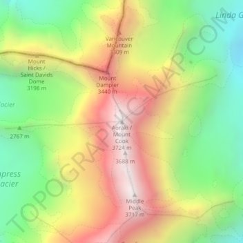
Naam: Topografische kaart Aoraki / Mount Cook, hoogte, reliëf.
Gemiddelde hoogte: 2.920 m
Minimale hoogte: 2.235 m
Maximale hoogte: 3.709 m
Andere topografische kaarten
Klik op een kaart om zijn topografie, zijn hoogte en zijn reliëf te bekijken.
Aua / King Billy Island
Nieuw-Zeeland > Canterbury > Christchurch City > Banks Peninsula Community
Aua / King Billy Island, Diamond Harbour, Banks Peninsula Community, Christchurch City, Canterbury, Nieuw-Zeeland
Gemiddelde hoogte: 6 m
Mt Bruce
Mt Bruce, Selwyn District, Canterbury, Nieuw-Zeeland
Gemiddelde hoogte: 1.264 m
Pegasus
Nieuw-Zeeland > Canterbury > Pegasus
Pegasus, Waimakariri District, Canterbury, 7612, Nieuw-Zeeland
Gemiddelde hoogte: 6 m
Mount Vancouver
Mount Vancouver, Mackenzie District, Canterbury, Nieuw-Zeeland
Gemiddelde hoogte: 2.804 m
Christchurch City
Christchurch City, Canterbury, Nieuw-Zeeland
Gemiddelde hoogte: 74 m
Selwyn District
Selwyn District, Canterbury, Nieuw-Zeeland
Gemiddelde hoogte: 679 m