
Topografische kaart Comanche County
Interactieve kaart
Klik op de kaart om de hoogte weer te geven.
Over deze kaart
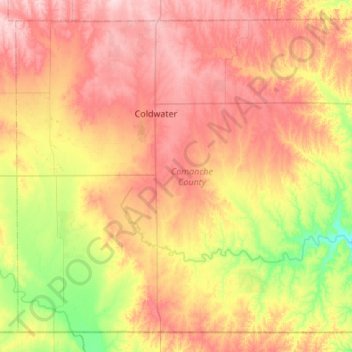
Naam: Topografische kaart Comanche County, hoogte, reliëf.
Locatie: Comanche County, Kansas, VS (36.99922 -99.54351 37.38493 -99.00068)
Gemiddelde hoogte: 595 m
Minimale hoogte: 491 m
Maximale hoogte: 699 m
Andere topografische kaarten
Klik op een kaart om zijn topografie, zijn hoogte en zijn reliëf te bekijken.