Geolokaliseren

Topografische kaart Flagstaff

Interactieve kaart

Klik op de kaart om de hoogte weer te geven.

Over deze kaart

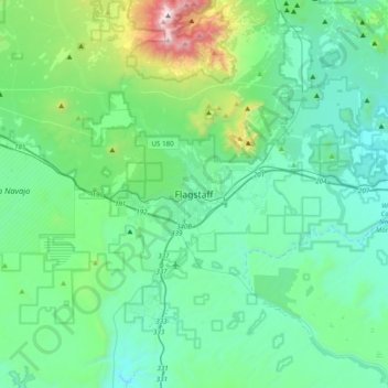
Naam: Topografische kaart Flagstaff, hoogte, reliëf.

Locatie: Flagstaff, Coconino County, Arizona, 86001, United States (35.03875 -111.81182 35.35875 -111.49182)

Gemiddelde hoogte: 2.230 m

Minimale hoogte: 1.895 m

Maximale hoogte: 3.836 m

Flagstaff, the county seat of Coconino County. According to the United States Census Bureau, the city has a total area of 63.9 square miles (165.5 km2), of which only 0.03 square miles (0.08 km2) (0.08%) is water. Flagstaff lies at approximately 7,000 feet (2,130 m) elevation, and is surrounded by the largest contiguous ponderosa pine forest in North America. It is in a mountainous area, and lies along the Rio de Flag watercourse. It is about 130 miles (210 km) north of the State capital, Phoenix.

Andere topografische kaarten

Klik op een kaart om zijn topografie, zijn hoogte en zijn reliëf te bekijken.

Buffalo Park

United States > Arizona > Coconino County > Flagstaff

Buffalo Park, East Flagstaff, Flagstaff, Coconino County, Arizona, United States

Gemiddelde hoogte: 2.159 m

Fay Canyon

United States > Arizona > Coconino County > Flagstaff

Fay Canyon, Flagstaff, Coconino County, Arizona, 86005, United States

Gemiddelde hoogte: 2.139 m