
Topografische kaart Erie County
Interactieve kaart
Klik op de kaart om de hoogte weer te geven.
Over deze kaart
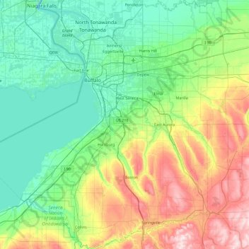
Naam: Topografische kaart Erie County, hoogte, reliëf.
Locatie: Erie County, New York, VS (42.43812 -79.13962 43.09870 -78.46281)
Gemiddelde hoogte: 286 m
Minimale hoogte: 156 m
Maximale hoogte: 649 m
Andere topografische kaarten
Klik op een kaart om zijn topografie, zijn hoogte en zijn reliëf te bekijken.
Bronxville
VS > New York > Bronxville > Town of Eastchester
Bronxville, Town of Eastchester, Westchester County, New York, 10708, VS
Gemiddelde hoogte: 48 m
Ellicottville
VS > New York > Ellicottville
Ellicottville, Cattaraugus County, New York, 14731, VS
Gemiddelde hoogte: 523 m
Head of the Harbor
VS > New York > Head of the Harbor
Head of the Harbor, Suffolk County, New York, VS
Gemiddelde hoogte: 35 m
Schenectady
VS > New York > Schenectady
Schenectady, Schenectady County, New York, VS
Gemiddelde hoogte: 100 m
Bramanville
VS > New York > Bramanville
Bramanville, Town of Cobleskill, Schoharie County, New York, 12092, VS
Gemiddelde hoogte: 320 m
Kings Park
VS > New York > Kings Park
Kings Park, Suffolk County, New York, 11754, VS
Gemiddelde hoogte: 37 m
Staten Island
Staten Island, Richmond County, NYC, New York, VS
Gemiddelde hoogte: 11 m
Port Washington
VS > New York > Port Washington
Port Washington, Nassau County, New York, VS
Gemiddelde hoogte: 22 m