
Topografische kaart Whitehorse
Interactieve kaart
Klik op de kaart om de hoogte weer te geven.
Over deze kaart
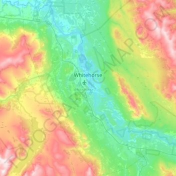
Naam: Topografische kaart Whitehorse, hoogte, reliëf.
Locatie: Whitehorse, Yukon, Canada (60.55364 -135.27872 60.84619 -134.85673)
Gemiddelde hoogte: 1.007 m
Minimale hoogte: 629 m
Maximale hoogte: 1.857 m
Andere topografische kaarten
Klik op een kaart om zijn topografie, zijn hoogte en zijn reliëf te bekijken.
Mount Logan
Tektonische activiteit in het gebied waar Mount Logan ligt, zorgt ervoor dat de berg aan hoogte wint.
Gemiddelde hoogte: 5.292 m