
Doe een donatie
Rust jezelf uit voor je volgende avontuur:
Als Amazon-partner verdient deze site een commissie op in aanmerking komende aankopen, zonder extra kosten voor jou.
Topografische kaart Hoover Dam
Klik op de kaart om de hoogte weer te geven.
Doe een donatie
Rust jezelf uit voor je volgende avontuur:
Als Amazon-partner verdient deze site een commissie op in aanmerking komende aankopen, zonder extra kosten voor jou.
Hoover Dam
De Hooverdam, ook wel bekend als de Boulderdam naar de op 12 km afstand gelegen plaats Boulder (Boulder City), is een betonnen boogdam in de Colorado ter hoogte van de Black Canyon (op de grens tussen de Amerikaanse staten Arizona en Nevada). De dam – die 48 kilometer ten zuidoosten van Las Vegas ligt – is genoemd naar Herbert Hoover die een sleutelrol speelde bij de bouw van de dam, eerst als Minister van Handel (Secretary of Commerce) en later als president van de Verenigde Staten. De Hooverdam werd gebouwd door Six Companies Incorporated, onder leiding van Frank Crowe. De bouw begon in 1930 en werd in 1936 afgerond, ruim twee jaar voor de geplande datum. De dam wordt uitgebaat door de Bureau of Reclamation van het Ministerie van Binnenlandse Zaken.
Doe een donatie
Rust jezelf uit voor je volgende avontuur:
Als Amazon-partner verdient deze site een commissie op in aanmerking komende aankopen, zonder extra kosten voor jou.
Over deze kaart
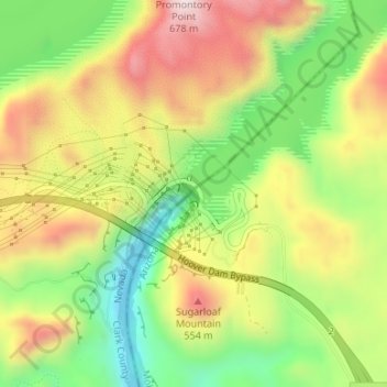
Naam: Topografische kaart Hoover Dam, hoogte, reliëf.
Locatie: Hoover Dam, Mohave County, Arizona, Verenigde Staten (36.01474 -114.73939 36.01674 -114.73673)
Gemiddelde hoogte: 429 m
Minimale hoogte: 197 m
Maximale hoogte: 682 m
Doe een donatie
Rust jezelf uit voor je volgende avontuur:
Als Amazon-partner verdient deze site een commissie op in aanmerking komende aankopen, zonder extra kosten voor jou.
Andere topografische kaarten
Klik op een kaart om zijn topografie, zijn hoogte en zijn reliëf te bekijken.
Lake Mead National Recreation Area
Verenigde Staten > Arizona > Mohave County
Gemiddelde hoogte: 949 m