
Topografische kaart Nadelhorn
Interactieve kaart
Klik op de kaart om de hoogte weer te geven.
Over deze kaart
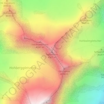
Naam: Topografische kaart Nadelhorn, hoogte, reliëf.
Locatie: Nadelhorn, Randa, Visp, Valais/Wallis, 3928, Zwitserland (46.10883 7.86401 46.10893 7.86411)
Gemiddelde hoogte: 3.765 m
Minimale hoogte: 2.967 m
Maximale hoogte: 4.456 m
Andere topografische kaarten
Klik op een kaart om zijn topografie, zijn hoogte en zijn reliëf te bekijken.
Weisshorn
Zwitserland > Valais/Wallis > Randa
Weisshorn, Randa, Visp, Valais/Wallis, 3928, Zwitserland
Gemiddelde hoogte: 3.595 m