
Topografische kaart Jammu
Klik op de kaart om de hoogte weer te geven.
Jammu
Jammu is de winterhoofdstad van het Indiase unieterritorium Jammu en Kasjmir. Na Srinagar (de zomerhoofdstad) is het de grootste stad van dit unieterritorium. Het is ook de hoofdplaats van het gelijknamige district Jammu en de gelijknamige historische regio Jammu. De stad ligt op 305 meter hoogte aan de rivier de Tawi.
Over deze kaart
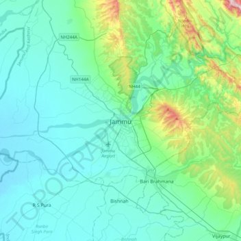
Naam: Topografische kaart Jammu, hoogte, reliëf.
Locatie: Jammu, Jammu District, Jammu en Kasjmir, 180001, India (32.55856 74.69809 32.87856 75.01809)
Gemiddelde hoogte: 367 m
Minimale hoogte: 255 m
Maximale hoogte: 987 m