
Topografische kaart Dumfries and Galloway
Interactieve kaart
Klik op de kaart om de hoogte weer te geven.
Over deze kaart
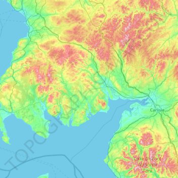
Naam: Topografische kaart Dumfries and Galloway, hoogte, reliëf.
Locatie: Dumfries and Galloway, Schotland, VK (54.63324 -5.18765 55.46405 -2.85733)
Gemiddelde hoogte: 163 m
Minimale hoogte: -1 m
Maximale hoogte: 921 m
Andere topografische kaarten
Klik op een kaart om zijn topografie, zijn hoogte en zijn reliëf te bekijken.
Old Polmont
VK > Schotland > Old Polmont
Old Polmont, Falkirk, Schotland, FK2 0XZ, VK
Gemiddelde hoogte: 37 m
Greenbraehead
VK > Schotland > Greenbraehead
Greenbraehead, Scottish Borders, Schotland, TD9 9SW, VK
Gemiddelde hoogte: 187 m
Carnoustie
VK > Schotland > Carnoustie
Carnoustie, Angus, Schotland, DD7 6AE, VK
Gemiddelde hoogte: 24 m
Loch Lubnaig
VK > Schotland > Ardchullarie More
Loch Lubnaig, A84, Ardchullarie More, Stirling, Schotland, FK17 8HF, VK
Gemiddelde hoogte: 382 m
Inverasdale
VK > Schotland > Inverasdale
Inverasdale, Highland, Schotland, IV22 2LW, VK
Gemiddelde hoogte: 54 m
Loch Lomond
Loch Lomond, A82, Tom Na Glas, Inverbeg, Argyll and Bute, Schotland, G83 8PD, VK
Gemiddelde hoogte: 240 m
Fort Augustus
VK > Schotland > Fort Augustus
Fort Augustus, Highland, Schotland, PH32 4AY, VK
Gemiddelde hoogte: 115 m