
Doe een donatie
Rust jezelf uit voor je volgende avontuur:
Als Amazon-partner verdient deze site een commissie op in aanmerking komende aankopen, zonder extra kosten voor jou.
Topografische kaart Istanboel
Klik op de kaart om de hoogte weer te geven.
Doe een donatie
Rust jezelf uit voor je volgende avontuur:
Als Amazon-partner verdient deze site een commissie op in aanmerking komende aankopen, zonder extra kosten voor jou.
Istanboel
Tegen 1600 werd het ruim duizend jaar tevoren gehaalde bevolkingsmaximum van een half miljoen weer gehaald, en zelfs iets overschreden (ca. 600.000). Het was nu een in etnisch en religieus opzicht heel gemengde stad geworden. De meerderheid van de bevolking (ca. 60%) was moslim en sprak Turks, maar er was ook een Griekse bevolkingsgroep (ca. 25%), die orthodox-christelijk was. Opmerkelijk genoeg hadden de Grieken nog steeds het grootste deel van de handel in handen. De resterende bevolking bestond grotendeels uit Joden en Armeniërs, maar in de wijk Sulukule had ook een flinke groep Roma zich gevestigd. Het Ottomaanse Rijk breidde zich gestaag uit totdat het rond 1750 het Midden-Oosten omvatte, het grootste deel van Noord-Afrika, de Balkan en het gebied rond de Zwarte Zee, wat opmerkelijk genoeg ongeveer hetzelfde gebied was dat het Byzantijnse Rijk omvatte op zijn hoogtepunt in de 6de eeuw. Op het eind van de 18e eeuw en gedurende de 19e eeuw onderging het Rijk een proces van degeneratie en verval, onder andere Griekenland en Egypte wisten zich zelfstandig te maken, en bleef het alleen overeind doordat de Europese machten het elkaar niet gunden om de definitieve genadeslag te geven aan de 'zieke man van Europa'.
Doe een donatie
Rust jezelf uit voor je volgende avontuur:
Als Amazon-partner verdient deze site een commissie op in aanmerking komende aankopen, zonder extra kosten voor jou.
Over deze kaart
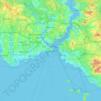
Naam: Topografische kaart Istanboel, hoogte, reliëf.
Locatie: Istanboel, Fatih, Istanboel, Marmararegio, 34122, Turkije (40.84638 28.81587 41.16638 29.13587)
Gemiddelde hoogte: 57 m
Minimale hoogte: -2 m
Maximale hoogte: 429 m
Doe een donatie
Rust jezelf uit voor je volgende avontuur:
Als Amazon-partner verdient deze site een commissie op in aanmerking komende aankopen, zonder extra kosten voor jou.