
Doe een donatie
Rust jezelf uit voor je volgende avontuur:
Als Amazon-partner verdient deze site een commissie op in aanmerking komende aankopen, zonder extra kosten voor jou.
Topografische kaart Kayseri
Klik op de kaart om de hoogte weer te geven.
Doe een donatie
Rust jezelf uit voor je volgende avontuur:
Als Amazon-partner verdient deze site een commissie op in aanmerking komende aankopen, zonder extra kosten voor jou.
Kayseri
Kayseri bevindt zich aan de voet van de beroemde berg Erciyes. Deze berg heeft een hoogte van 3916 meter en is vanuit de hele stad te zien. Voor veel toeristen is Erciyes een vrij onbekend skioord, doordat Kayseri vooral fungeert als een doorreislocatie naar de bekende toeristische attracties in Cappadocië.
Doe een donatie
Rust jezelf uit voor je volgende avontuur:
Als Amazon-partner verdient deze site een commissie op in aanmerking komende aankopen, zonder extra kosten voor jou.
Over deze kaart
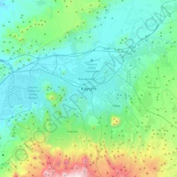
Naam: Topografische kaart Kayseri, hoogte, reliëf.
Locatie: Kayseri, Melikgazi, Kayseri, Centraal-Anatolië, 38050, Turkije (38.56190 35.32732 38.88190 35.64732)
Gemiddelde hoogte: 1.345 m
Minimale hoogte: 1.013 m
Maximale hoogte: 2.795 m
Doe een donatie
Rust jezelf uit voor je volgende avontuur:
Als Amazon-partner verdient deze site een commissie op in aanmerking komende aankopen, zonder extra kosten voor jou.