
Topografische kaart Genua
Klik op de kaart om de hoogte weer te geven.
Over deze kaart
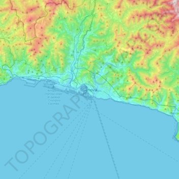
Naam: Topografische kaart Genua, hoogte, reliëf.
Locatie: Genua, Ligurië, 16100, Italië (44.24726 8.77386 44.56726 9.09386)
Gemiddelde hoogte: 247 m
Minimale hoogte: -4 m
Maximale hoogte: 1.486 m
Andere topografische kaarten
Klik op een kaart om zijn topografie, zijn hoogte en zijn reliëf te bekijken.