
Topografische kaart Imphal East District
Interactieve kaart
Klik op de kaart om de hoogte weer te geven.
Over deze kaart
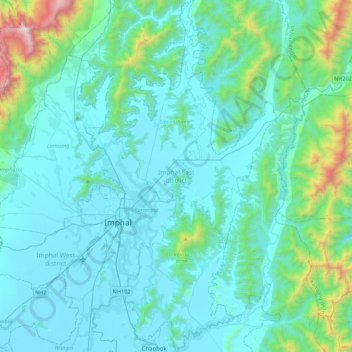
Naam: Topografische kaart Imphal East District, hoogte, reliëf.
Locatie: Imphal East District, Manipur, India (24.65151 93.89542 25.05120 94.13485)
Gemiddelde hoogte: 982 m
Minimale hoogte: 767 m
Maximale hoogte: 2.498 m
Imphal East District came into existence on 18-06-1997 with its headquarters at Porompat occupying the eastern part of Imphal District. The total area of District is 497 km2. approximately. The District is situated at an altitude 790 metres above the M.S. Level. The climate of the District is salubrious and Monsoon is tropical. The minimum temperature goes down to 0.6 degree Celsius in winter and 41 degree Celsius in summer. It has no rail network and hence communication is entirely dependent on roads except Jiribam District bordering Cachar District of Assam where there is a railhead. As of 2017, A new rail line is under construction and a railway station will be operational by 2019. The District is connected with N.H. 39, N.H. 53 and N.H. 150.
Andere topografische kaarten
Klik op een kaart om zijn topografie, zijn hoogte en zijn reliëf te bekijken.
Kwatha Meitei
India > Manipur > Tengnoupal tehsil
Kwatha Meitei, Tengnoupal tehsil, Tengnoupal District, Manipur, India
Gemiddelde hoogte: 476 m
Senapati
India > Manipur > Senapati tehsil
Senapati, Senapati tehsil, Senapati District, Manipur, India
Gemiddelde hoogte: 1.321 m
Loktak Lake
India > Manipur > Bishnupur > Moirang
Loktak Lake, Moirang, Bishnupur, Manipur, India
Gemiddelde hoogte: 771 m
Chingmai Khullen
Chingmai Khullen, Paomata, Senapati, Manipur, India
Gemiddelde hoogte: 1.454 m
Nambul River
Nambul River, Imphal, Lamphelpat, Imphal West, Manipur, 795001, India
Gemiddelde hoogte: 779 m
Moreh
India > Manipur > Tengnoupal tehsil
Moreh, Tengnoupal tehsil, Tengnoupal District, Manipur, 795131, India
Gemiddelde hoogte: 270 m
Khuga Dam
India > Manipur > Churachandpur
Khuga Dam, Churachandpur, Manipur, India
Gemiddelde hoogte: 849 m
Ningthoukhong
India > Manipur > Ningthoukhong
Ningthoukhong, Moirang, Bishnupur, Manipur, 795126, India
Gemiddelde hoogte: 777 m
Imphal
India > Manipur > Lamphelpat
Imphal, Lamphelpat, Imphal West, Manipur, 795001, India
Gemiddelde hoogte: 861 m