
Topografische kaart Attica
Interactieve kaart
Klik op de kaart om de hoogte weer te geven.
Over deze kaart
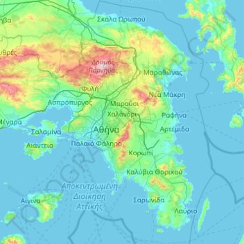
Naam: Topografische kaart Attica, hoogte, reliëf.
Locatie: Attica, Griekenland (37.64831 23.10669 38.34101 24.08594)
Gemiddelde hoogte: 133 m
Minimale hoogte: -1 m
Maximale hoogte: 1.384 m
Andere topografische kaarten
Klik op een kaart om zijn topografie, zijn hoogte en zijn reliëf te bekijken.
Δήμος Ωρωπού
Griekenland > Attica > Περιφερειακή Ενότητα Ανατολικής Αττικής
Δήμος Ωρωπού, Περιφερειακή Ενότητα Ανατολικής Αττικής, Attica, Griekenland
Gemiddelde hoogte: 333 m
Athene
Griekenland > Attica > Περιφερειακή Ενότητα Κεντρικού Τομέα Αθηνών
Athene, Δήμος Αθηναίων, Περιφερειακή Ενότητα Κεντρικού Τομέα Αθηνών, Attica, 104 31, Griekenland
Gemiddelde hoogte: 178 m
Δημοτική Ενότητα Μοσχάτου
Griekenland > Attica > Περιφερειακή Ενότητα Νοτίου Τομέα Αθηνών
Δημοτική Ενότητα Μοσχάτου, Δήμος Μοσχάτου-Ταύρου, Περιφερειακή Ενότητα Νοτίου Τομέα Αθηνών, Attica, Griekenland
Gemiddelde hoogte: 11 m
Olympus
Griekenland > Attica > Περιφερειακή Ενότητα Βορείου Τομέα Αθηνών > Δημοτική Ενότητα Ψυχικού
Olympus, Δημοτική Ενότητα Ψυχικού, Δήμος Φιλοθέης - Ψυχικού, Περιφερειακή Ενότητα Βορείου Τομέα Αθηνών, Attica, 154 52, Griekenland
Gemiddelde hoogte: 204 m
Αγκώνα
Griekenland > Attica > Περιφερειακή Ενότητα Ανατολικής Αττικής
Αγκώνα, Δήμος Ωρωπού, Περιφερειακή Ενότητα Ανατολικής Αττικής, Attica, 190 17, Griekenland
Gemiddelde hoogte: 24 m
Μαραθώνας
Griekenland > Attica > Μαραθώνας
Μαραθώνας, Marathónas, Περιφερειακή Ενότητα Ανατολικής Αττικής, Attica, 19007, Griekenland
Gemiddelde hoogte: 157 m